|
E. James Dixon University of Colorado
Geography during the last Ice Age limited possible migration routes available
to the first humans to colonize the Americas. The preponderance of linguistic
and biological evidence indicates that Native Americans most likely originated
somewhere in northeastern Asia. Two possible routes have been identified
for the first humans to enter the Americas from Northeast Asia: by watercraft
along the Northwest Coast, or by a pedestrian terrestrial route across the
Bering Land Bridge and then south through central-western Canada. There is
a growing body of evidence suggesting that the mostplausible route for the
initial colonization of the Americas may have been along the Northwest Coast,
beginning possibly as early as 14,000 radiocarbon years ago (16,300 calendar
years BP).
Evaluating the evidence for the first human colonization of the Americas
rests on dating geological events, human remains, artifacts, and other
archaeological evidence. In some publications radiocarbon dates are used,
and in other articles dates are recalibrated to indicate calendar years before
the present (cal BP). When radiocarbon dates are calibrated to calendar years
it is apparent that there is more time for human colonization and settlement
than is suggested by using only the radiocarbon time scale. For consistency
both dates are presented in this article. Because it is difficult to calibrate
radiocarbon determinations older than about 15,000 years, these dates are
reported only as radiocarbon dates.
The Continental Route: Traditionally scientists have believed that
the first humans to colonize the Americas arrived during the last Ice Age,
or Pleistocene, via the Bering Land Bridge. The climate was much colder then,
and massive glaciers in eastern and western Canada formed a huge ice sheet
covering most of the country. The ice blocked access between what is today
Alaska and the contiguous United States. Polar sea ice extended south into
the Atlantic, covering Greenland, 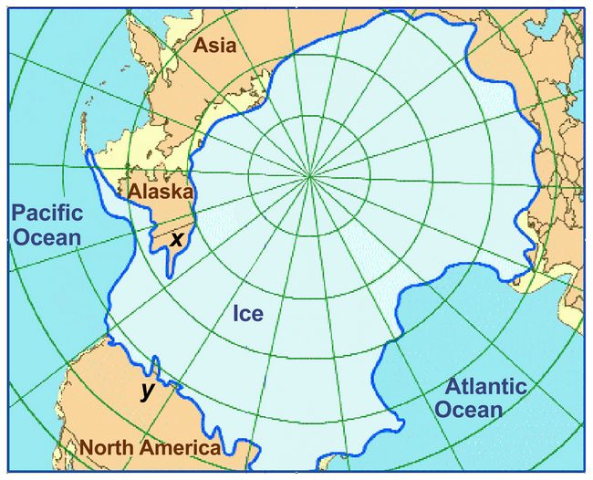 Iceland, and all but the southernmost areas
of Ireland and England (fig.1). Because much of the earth’s water was
trapped in glacial ice, sea level was lower. The continental shelves and
the floor of the Bering and Chukchi Seas were exposed, creating the Bering
Land Bridge, which, along with adjacent regions of Siberia and North America,
formed a geographic area known as Beringia. Iceland, and all but the southernmost areas
of Ireland and England (fig.1). Because much of the earth’s water was
trapped in glacial ice, sea level was lower. The continental shelves and
the floor of the Bering and Chukchi Seas were exposed, creating the Bering
Land Bridge, which, along with adjacent regions of Siberia and North America,
formed a geographic area known as Beringia.
Fig.1: North polar projection depicting the extent of glacial ice at the
height of the last Ice Age, about 18,000 radiocarbon years ago. The
“x” and “y” labels at lower left show the approximate
location of the hypothetical “ice-free corridor” in western Canada
(see also fig.2).
The idea that humans may have first entered the Americas via a land route
in the high northern latitudes was first suggested by a Spanish priest more
than 400 years ago and over time this concept has become deeply rooted in
scientific thought. It is believed that these early colonists were adapted
to the interior environments of Asia and hunted large Ice Age animals, including
the extinct woolly mammoth, as well as other species that did not become
extinct such as bison. According to this theory, after these early people
had crossed the Land Bridge into Alaska they then moved south into
central-western Canada and from there to more southern areas of North America
and eventually into South America.
During the height of the last Ice Age, massive glaciers covered much of northern
North America. The first humans to enter the region would have been confronted
by a seemingly endless icescape reaching from Canada’s Yukon Territory
in the north to the Great Lakes in the south. The continental glaciers would
have blocked human migration southward until the ice melted sufficiently
to enable plants and animals to colonize the deglaciated land.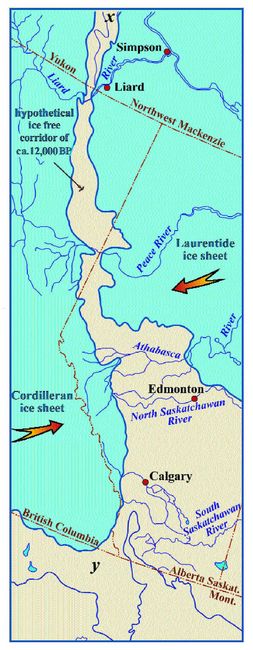 Several researchers have hypothesized that an “ice-free corridor”
may have existed in the region of central-western Canada (fig.2). They further theorized that this hypothetical “corridor” could have provided
an avenue through which humans may have passed from Beringia to the more
southern regions of the continent prior to the end of the last Ice Age. This
ice-free corridor concept was used to explain the discovery of archaeological
evidence south of the continental glaciers believed to be older than 11,500
BP (13,050 cal BP) and predating the melting of the glaciers.
Fig.2: Hypothetical “ice-free corridor” (linking points “x”
and “y” in fig.1), a narrow passage bound by the Cordilleran and
Laurentide glaciers that some researchers suggest may have been open periodically
between 30-12,000 BP. The Clovis model hypothesizes that Paleoindians passed
through here around 11,500 BP to reach the rest of the New World, but new
evidence suggests that a coastal route would have been open earlier and more
hospitable for human immigrants (after Prest 1969). Exciting new discoveries are causing some researchers to question many of
these traditional concepts. For example, geologists working in Canada have
recently demonstrated that the “ice-free corridor” did not exist,
and that connections between eastern Beringia and areas south of the continental
glaciers probably were not established until about 11,000 BP (12,550 cal
BP). Radiocarbon dates previously used to support the existence of an ice-free
corridor or that suggest early deglaciation of central Canada have proven
inaccurate (MacDonald 1987). The distribution of quartzite erratics (large
rocks transported by glaciers) derived near the headwaters of Alberta’s
Athabasca River (Jackson et al. 1997) demonstrates the coalescence of the
Cordilleran and Laurentide ice over an extensive area in southern Alberta
(Jackson et al. 1996) and that the coalesced continental glaciers did not
melt in southern Alberta until sometime about 12,000-11,000 BP (13,600-12,550
cal BP) (Jackson et al. 1996:223).
Recent studies demonstrate that Beringia and the unglaciated areas of North
America remained separated by the continental glacier until about 11,000
BP (12,550 cal BP) when the glaciers had melted enough to enable people to
move from eastern Beringia southward into the lower latitudes of North America
(Rutter 1984, Clague et al. 1989, Jackson and Duk-Rodkin 1996, Jackson et
al. 1997). Because the ice sheets blocked this southern route, the North
American continent south of the glaciers could not have been colonized by
humans on foot until sometime about 11,000 BP (12,550 cal BP). Support for
this conclusion has been presented by paleontologists working in central
Canada. They have found no animal bones dating between about 21,000 to 11,500
BP (until 13,050 cal BP) in the region formerly believed to be the ice-free
corridor (Burns 1996). This demonstrates fairly conclusively that the ice-free
corridor did not exist and that the glaciers prevented the area from being
inhabited by animals during the last Ice Age. This evidence precludes a
mid-continental route for human entry before about 11,500 to 11,000 BP
(13,050-12,550 cal BP).
While this geological research has been taking place in Canada, important
archaeological evidence has been accumulating at sites across North and South
America. There are numerous sites throughout the Americas believed by some
researchers to be older than 11,500 BP (fig.3). While the age and cultural
origin of these sites are considered controversial by some researchers, this
growing body of data strongly supports the concept that humans were widespread
throughout the Americas prior to the melting of the continental glaciers
approximately 11,500-11,000 BP (13,100-12,550 cal BP).
Human Remains: One way to evaluate the timing of the first human
colonization of the Americas is to analyze the ages of the oldest reliably
dated human skeletal remains from North America. The three oldest sets of
well dated human remains from North America are from Fishbone Cave in western
Nevada; Arlington Springs on Santa Rosa Island off the coast of California;
and the Anzick site in Montana. Radiocarbon dates of 11,555 +/- 500 BP (13,540
cal BP) and 10,900 +/- 300 BP (12,900 cal BP) were reported from a stratigraphic
level at Fishbone Cave containing the burned bones of a human foot, clavicle
(collar bone), and a fibula (lower leg bone). On Santa Rosa Island human
bones have recently been redated by Johnson and Stafford to 10,970 +/- 80
BP (12,980 cal BP) (Johnson et al. 2000). Bone sampled from a human cranium
stained with red ochre found at the Anzick rock shelter in Montana has two
somewhat conflicting radiocarbon dates, one of 10,680 +/- 50 BP (12,840 cal
BP) and another of 11,550 +/- 60 BP (13,470 cal BP).
The early radiocarbon dates from all three individuals demonstrate that humans
had arrived in North America by about 11,500-11,000 BP (13,050-12,550 cal
BP). By this time human population density in North America had achieved
a level sufficient to assure the survival and discovery of fossil remains
over broad geographic areas. It is unlikely that these examples represent
the remains of North America’s earliest inhabitants, because the initial
human population was probably very small. As the number of individuals increased
over time, the chances of discovering their remains increase. It is extremely
unlikely that the remains of the very first inhabitants of North America
will ever be found. Radiocarbon dated human skeletal materials provide limiting
dates for the arrival of humans in the Americas sometime prior to circa 11,500
BP (13,050 cal BP), with no reliably dated human remains from the Americas
before then. This and other evidence suggests humans may have first arrived
in the Americas no more than approximately 14,000 BP (16,250 cal BP) or 15,000
BP (16,950 cal BP), near the end of the last Ice Age.
Coastal Migration Hypothesis: If the first Americans could not walk
across the continental glaciers south into the New World, how could they
have gott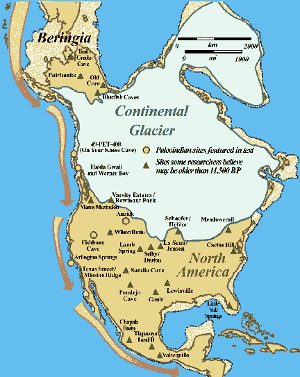 en there prior to the melting of the ice sheets? A few researchers
(Fladmark 1979, 1983, Dixon 1993, Gruhn 1994) suggest that the earliest human
migration to North America may have occurred with the use of watercraft along
the southern margin of Beringia and then southward along the northwest coast
of North America (fig.3). This would have enabled humans to enter southern
areas of the Americas prior to the melting of the mid-continental glaciers.
Some scientists believe migration from Beringia into the Americas may have
begun as early as 50,000 BP, or possibly earlier, while others suggest it
may have been as late as 12,000-11,000 BP (13,550-12,550 cal B en there prior to the melting of the ice sheets? A few researchers
(Fladmark 1979, 1983, Dixon 1993, Gruhn 1994) suggest that the earliest human
migration to North America may have occurred with the use of watercraft along
the southern margin of Beringia and then southward along the northwest coast
of North America (fig.3). This would have enabled humans to enter southern
areas of the Americas prior to the melting of the mid-continental glaciers.
Some scientists believe migration from Beringia into the Americas may have
begun as early as 50,000 BP, or possibly earlier, while others suggest it
may have been as late as 12,000-11,000 BP (13,550-12,550 cal B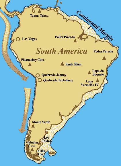 P). P).
Fig.3: Map
of the Western Hemisphere, illustrating the hypothetical coastal migration
route that may have been open to human colonists using watercraft possibly
as early as14,000 radiocarbon years ago (16,250 cal BP).
The coastal migration hypothesis has gained increased support in recent years,
because the remains of black and brown bears and other terrestrial animals
have been found in Southeast Alaska dating between 12,500 and 10,000 BP
(14,150-10,900 cal BP) (Heaton 1995, 1996, Heaton and Grady 1993, Heaton
et al. 1996). Because the diets of the large omnivores are very similar to
the diets of humans, these discoveries demonstrate that sufficient subsistence
resources were available to support people. The remains of land and sea mammals
including caribou, seals, birds, and fish dating to this time have also been
discovered along the Northwest Coast. These finds provide additional evidence
that there were ample resources for people to survive.
Prior to the early 1970s it had been assumed that the Cordilleran ice extended
westward to the margins of the continental shelf (Coulter et al. 1965, Nasmith
1970, Prest 1969) thus creating a barrier to human migration. More recently,
geologists working in Southeast Alaska and British Columbia have discovered
that deglaciation along the Northwest Coast of North America had begun by
about 14,000 BP (16,800 cal BP) and was sufficiently advanced to enable humans
using watercraft to colonize coastal areas by 13,000 BP (15,350 cal BP).
Geologic and paleoecological studies document deglaciation and the existence
of ice-free areas throughout major coastal regions of British Columbia by
about 13,000 BP (14,850 cal BP) (Blaise et al. 1990, Bobrowsky et al. 1990).
It is now clear that areas of continental shelf and offshore islands were
not covered by ice during and toward the end of the last glacial period.
Vast coastal stretches may have been deglaciated beginning about 16,000 BP.
Except for a 400 km coastal area between southwest British Columbia and
Washington State, the Northwest Coast of North America was largely free of
ice by about 16,000 BP (Mann and Peteet 1994). The exposed continental shelf
and offshore islands were available as a migration route between 13,500 and
9,500 BP (14,850-10,150 cal BP) (Josenhans et al. 1997), possibly enabling
people to colonize ice-free regions along the continental shelf exposed by
lower sea level.
The earliest archaeological evidence is represented by a group of artifacts,
called the Northwest Coast Microblade tradition, found at a number of
archaeological sites along the Northwest Coast (fig.4). The Northwest Coast
Microblade tradition is documented as early as circa 9,500 BP (10,150 cal
BP) in British Columbia and Southeast Alaska. It has not been determined,
however, when this tradition first appeared along the Northwest Coast. Rising
sea level inundated most coastal sites older than ca. 9,500 BP (10,150 cal
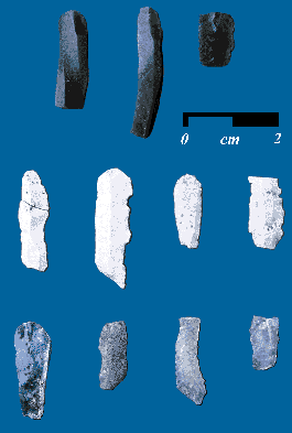
BP). Fig.4: Microblades characteristic of the Northwest Coast Microblade tradition
found at 49-PET-408, Prince of Wales Island, Southeast Alaska (photo: E.
James Dixon). Archaeological sites ascribed to this tradition share the use of microblades,
small parallel-sided stone artifacts used for a variety of specialized purposes
(fig.4). These sites exhibit a marine economy documented by limited terrestrial
faunal remains and ecological settings on ancient beaches, and other geographic
features oriented to exploiting marine resources. Northwest Coast Microblade
tradition subsistence practices were adapted to an environment characterized
by year round open water; rugged coast with fjords, islands, and rocky headlands;
calving glaciers; major salmon runs; and intertidal shellfish. These complex
traits were probably preceded by a long developmental process, suggesting
that regional adaptation began much earlier.
Because previous geologic interpretations indicated that the region had been
entirely glaciated until about 10,000 BP (10,900 cal BP), very little
archaeological work has been undertaken to explore this region as a possible
migration route. archaeological evidence necessary to evaluate the coastal
migration hypothesis is difficult to detect because rising sea level at the
close of the Pleistocene inundated much of the continental shelf. Some pioneering
efforts are under way, however, including archaeological and paleontological
excavations at an important cave site known as 49-PET-408, on Prince of Wales
Island in Southeast Alaska (figs.5-9).
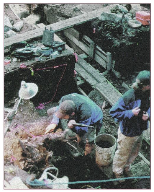
Fig.5: Excavations at entrance of 49-PET-408 (Eric Parrish). Site 49-PET-408: Excavations at 49-PET-408 (On Your Knees Cave; figs.5,6)
provide important new insights into the character and timing of the climatic
transition at the end of the Pleistocene, as well as the human response to
this climate change. The objectives of the interdisciplinary research program
developed from cooperation between Native people, scientists, and federal
resource managers. This synergy has led to the discovery of new evidence
important to evaluating the Northwest Coast migration hypothesis and supports
the concept that the first human colonization of the Americas at the end
of the last Ice Age may have occurred with the use of watercraft along the
north Pacific Rim.
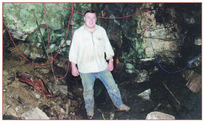
Fig.6: Archaeologist E. James Dixon in front of the main entrance to the
cave site, 49-PET-408 during the 2000 field season (photo: Eric Parrish). The most extensive use of the cave occurred between approximately 9,500 and
8,500 BP (10,150-9,050 cal BP). This stratigraphic level contains microblades
made of obsidian and other exotic types of stone, bifaces (fig.7), flakes,
cores, and other tools. 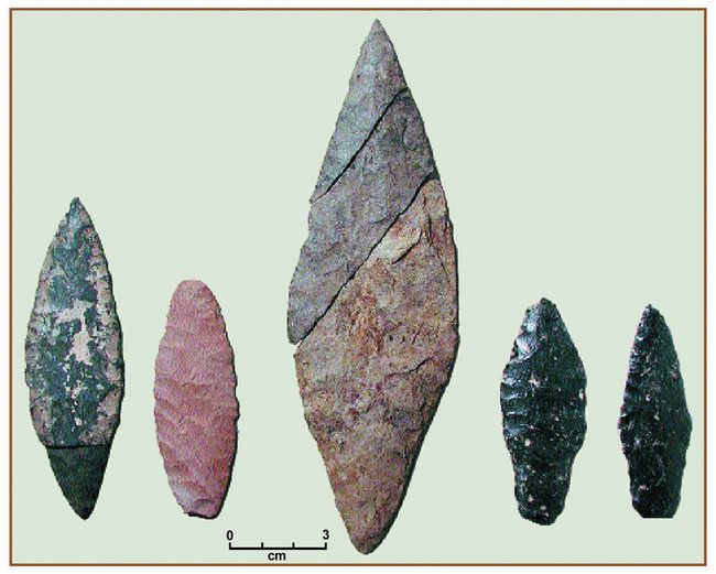
The oldest human skeletal remains know n from Alaska or Canada are also associated
with this level. The partial remains of an adult male have been found scattered
throughout the cave. The pelvis, or hip, has bee n dated to 9,880 +/- 50 BP
(11,230 cal BP) and the mandible, or jaw, to 9,730 +/- 60 BP (11,150 cal
BP) (Dixon et al. 1997, Dixon 1999).
Fig.7: Bifacially flaked stone artifacts from 49-PET-408 (photo: Eric Parrish). Isotopic analysis demonstrates that
the individual was raised on a diet of marine foods and that the radiocarbon
age should be adjusted to about 9,200 radiocarbon years based on the regional
marine carbon reservoir (Josenhans et al. 1997). Radiocarbon dates suggest
that the human remains are contemporaneous with the oldest microblades, bifaces,
and other stone tools recovered from the cave.
Trace element analysis of some of the artifacts made from volcanic glass,
or obsidian, demonstrates that the obsidian came from at least two different
sources, Mount Edziza on the British Columbia mainland and Sumez Island in
Southeast Alaska (Lee 2001) (fig.8). Because Prince of Wales Island was not
connected to the mainland at the time the cave was occupied, it could only
have reached the site by being transported by humans using water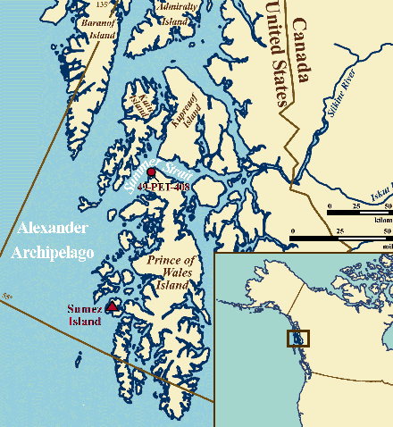 craft. craft.
There is additional tantalizing information from the cave. An undated
stratigraphic unit underlying the level containing the microblades and other
artifacts contains a few stone flakes. This could be possible evidence of
an earlier human occupation. A tool made from the bone of a terrestrial mammal
found in an interior chamber of the cave has been radiocarbon dated by the
AMS method (accelerator mass spectrometry, providing accurate dates using
smaller samples) to 10,300 +/- 50 BP (12,070 cal BP) and is the oldest reliably
dated artifact from the Northwest Coast of North America (fig.9).
Fig.8: Map depicting the location of 49-PET-408 on Prince of Wales Island
and obsidian sources on Sumez Island and Mt. Edziza (Eric Parrish).
The research at 49-PET-408 suggests that humans were adapted to the maritime
environments of the Northwest Coast by ca. 9,500 BP (10,150 cal BP), and
probably much earlier. Collectively, the data from this important site indicate
that humans along the Northwest Coast were experienced coastal navigators
with an economy based on maritime subsistence and established trade networks
for obsidian by 10,000-9,000 BP (10,900-9,60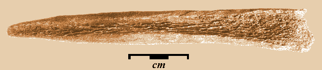 0 cal BP). This further implies
even earlier human occupation in order to establish this broad regional
adaptation by circa 10,000 BP (10,900 cal BP). 0 cal BP). This further implies
even earlier human occupation in order to establish this broad regional
adaptation by circa 10,000 BP (10,900 cal BP).
Fig.9: Bone tool found in a chamber of cave site 49-PET-408 dated by accelerator
mass spectrometry (AMS) to 10,300 radiocarbon years before present, which
documents late Pleistocene use of the cave (photo: E. James Dixon). Other Discoveries: Additional evidence of early maritime adaptation
and the use of watercraft is beginning to accumulate from a variety of sites
along the west coast of the Americas. A basalt blade-like artifact was recovered
from an underwater site on the continental shelf of British Columbia. Based
on the local rise in sea level at the end of the last Ice Age, this locale
would probably have been covered by the rising ocean about or shortly before
10,000 BP (10,900 cal BP), thus suggesting the site may have been occupied
prior to that time (Fedje, this issue, p.28).
Further south along the coast of California, Arlington Man, found on Santa
Rosa Island, provides the earliest evidence for the use of watercraft in
North America, at approximately 11,000 BP (12,550 cal BP). As Santa Rosa
Island was not connected to mainland North America during the last Ice Age,
the only plausible way this individual could have reached it was with the
use of watercraft, or to have been the descendent of individuals who arrived
by watercraft (Erlandson 1994:183).
The coastal migration hypothesis is also supported by evidence from several
archaeological sites discovered along the west coast of South America. At
the Las Vegas site in southwestern Ecuador, marine fish and shellfish have
been recovered from a habitation site dating between 10,840 and 10,100 BP
(circa 11,750 cal BP) (Stothert 1998, Wisner 1999). Further south at Quebrada
Tachahuay, Peru, located less than 0.5 km (0.3 mi) from the Pacific Ocean,
a human occupation dating between 11,000 BP (12,550 cal BP) and 10,500 BP
(11,750 cal BP) contains the remains of fish, marine birds, and stone tools
(Keefer et al. 1998). At another Peruvian site, Quebrada Jaguay, there are
remains of marine fish, shells, cordage (possibly fishnet), stone flakes,
and tools (Sandweiss et al. 1998). At the time the site was occupied, it
would have been located approximately 7 or 8 km (4 or 5 mi) from the ocean.
Collectively these sites are beginning to reveal a glimpse of very early
coastal adaptations along the Pacific coast of the Americas at the end of
the last Ice Age.
Summary: There is a growing body of data that suggests the first human
colonization of the Americas could have occurred along the west coast of
the Americas with the use of watercraft, possibly skin boats, near the end
of the last Ice Age, perhaps as early as 14,000 BP (16,250 cal BP). This
hypothesis is supported by recent archaeological discoveries along the west
coast of the Americas that suggest a widespread pattern of maritime adaptation
and coastal navigation as early as 11,000 to 10,000 BP (12,550-10,900 cal
BP). If the theory is correct, the oldest archaeological sites in the Americas
should be located along the western coast.
The interior “ice-free corridor” model for human colonization requires
an economy based on hunting terrestrial mammals, fresh water fishing, and
pedestrian travel. By contrast, the coastal hypothesis suggests an economy
based on marine mammal hunting, salt water fishing/shellfish gathering, and
the use of watercraft. It is important to address these hypotheses because
each requires different types of adaptations by the New World founding
population. Understanding the timing and processes of colonization of the
Americas is important because the cultural adaptations of the New World’s
first populations established the foundation for all subsequent cultural
development and for the rich and diverse cultures that followed. If the coastal
colonization hypothesis is to be fully evaluated, the late Pleistocene coastal
archaeology of western North America will require additional and sustained
research efforts equivalent to those that have traditionally focused on
mid-continental North America.
References:
Acknowledgements: I thank colleagues, Doug Bamforth, Cathy Cameron,
Frank Eddy, John Hoffecker, Art Joyce, Stephen Lekson, and Payson Sheets
at the University of Colorado for their review and comments on an earlier
version of this manuscript. Eric Parrish provided valuable photographic and
graphic assistance in preparing this manuscript.
Bibliography:
Blaise, B., J.J. Clague, and R.W. Mathewes. 1990. “Time of Maximum Late
Wisconsin Glaciation, West Coast of Canada.” Quaternary
Research 34:282-295.
Bobrowsky, P.T., N.R. Catto, J.W. Brink, B.E. Spurling, T.H. Gibson, and
N.W. Rutter. 1990. “Archaeological Geology of Sites in Western and
Northwestern Canada.” Centennial Special Vol. 4. pp.87-122.
Geological Society of America, Boulder.
Burns, J.A. 1996. “Vertebrate Paleontology and the Alleged Ice-Free
Corridor: The Meat of the Matter.” Quaternary International
Vol.32, pp.107-112. Great Britain.
Clague, J.J., et al. 1989. “Chapter 1. Quaternary Geology of the Canadian
Cordillera.” In R.J. Fulton (ed.) Quaternary Geology of Canada
and Greenland. Geological Society of Canada, Geology of Canada, no.
1.
Coulter, H.W., D.M. Hopkins, T.N.V. Karlstom, T.L. Pewe, C. Wahrhaftig, and
J.R. Williams. 1965. “Map showing extent of glaciations in Alaska.”
In U.S. Geological Survey Miscellaneous Geologic
Investigations. Map, I-415, scale 1:2,500,000.
Dillehay, T.D. 1984. “A Late Ice-Age Settlement in Southern Chile.”
Scientific American 251(4):100-109.
Dixon, E. James. 1993. Quest for the Origins of the First
Americans. Univ. of New Mexico Press, Albuquerque.
Dixon, E. James. 1999. Bones, Boats, and Bison: Archeology and the
First Colonization of Western North America. University of New Mexico
Press, Albuquerque.
Dixon, E. James, T. H. Heaton, T. E. Fifield, T. D. Hamilton, D. E. Putnam
and F. Grady. 1997. “Late Quaternary Regional Geoarchaeology of Southeast
Alaska Karst: A Progress Report.” Geoarchaeology: An International
Journal 12(6):689-712.
Erlandson, J.M. 1994. Early Hunter-Gatherers of the California
Coast. Plenum Press, New York, London.
Fedje, D.W., A.P. Mackie, J.B. McSporran, and B. Wilson. 1996. “Early
Period Archaeology in Gwaii Haanas: Results of the 1993 Field Program.”
In R.L. Carlson and L. Dalla Bona (eds.) Early Human Occupation in
British Columbia. pp.133-150. Univ. of British Columbia Press.
Fladmark, K.R. 1979. “Routes: Alternative Migration Corridors for Early
Man in North America.” American Antiquity 44:55-69.
Fladmark, K.R. 1983. “Times and Places: Environmental Correlates of
Mid-to-Late Wisconsin Human Population Expansion in North America.”
In R. Shutler (ed.) Early Man in the New World. pp.13-42. Sage
Publication, Beverly Hills.
Gruhn, R. 1994. “The Pacific Coast Route of Initial Entry: An
Overview.” In R. Bonnichsen and D.G. Steele (eds.) Method and
Theory for Investigating the Peopling of the Americas. Center for
the Study of the First Americans, Oregon State Univ., Corvallis.
Heaton, T.H. 1995. “Middle Wisconsin Bear and Rodent Remains Discovered
on Prince of Wales Island, Alaska.” Current Research in the
Pleistocene 12:92-95.
Heaton, T.H. 1996. “The Late Wisconsin Vertebrate Fauna of On Your Knees
Cave, Northern Prince of Wales Island, Alaska.” Journal of Vertebrate
Paleontology 16:40A-41.
Heaton, T.H. 1993. “Fossil Grizzly Bears from Prince of Wales Island,
Alaska, Offer New Insights into Animal Dispersal, Interspecific Competition,
and Age of Deglaciation.” Current Research in the
Pleistocene 10:98-100.
Heaton, T.H., S.L. Talbot and G.F. Shield. 1996. “An Ice Age Refugium
for Large Mammals in the Alexander Archipelago, Southeastern Alaska.”
Quaternary Research 46(2):186-192.
Jackson, L.E. Jr., and A. Duk-Rodkin. 1996. “Quaternary geology of the
ice-free corridor: glacial controls on the peopling of the New World.”
In T. Akazawa and E.J.E. Szathmary (eds.) Prehistoric Mongolo and
Dispersals. Oxford Univ. Press.
Jackson, L.E., Jr., F.M. Phillips, K. Shimamura, and E.C. Little. 1997.
“Cosmogenic 36Cl dating of the Foothills erratics train, Alberta,
Canada.” Geology 25(3):195-198.
Johnson, J.R., T.W. Stafford, H.O Ajie and D.P. Morris. 2000. “Arlington
Springs revisited.” Proceedings of the Fifth California Islands
Symposium. pp.541-45.
Josenhans, H.W., D.W. Fedje, R. Pienitz, and J. Southon. 1997. “Early
Humans and Rapidly Changing Holocene Sea Levels in the Queen Charlotte
Islands-Hecate Strait, British Columbia, Canada.”
Science 277:71-74.
Keefer, D.K., S.D. deFrance, M.E. Moseley, J.B. Richardson III, D.R. Satterlee,
A. Day-Lewis. 1998. “Early Maritime Economy and el Nińo Events
at Quebrada Tacahuay, Peru.” Science 281:1833-1835.
Lee, C.M. 2001. Microblade Morphology and Trace Element Analysis: An
Examination of Obsidian Artifacts from Archaeological Site 49-PET-408, Prince
of Wales Island, Alaska. Unpublished MA Thesis, Univ. of Wyoming,
Laramie.
Mann, D.H., and D.M. Peteet. 1994. “Extent and Timing of the Last Glacial
Maximum in Southwestern Alaska.” Quaternary Research
42(2):136-148.
MacDonald, G.M. 1987. “Postglacial Vegetation History of the Mackenzie
River Basin.” Quaternary Research 28(2):245-262.
Nasmith, H.W. 1970. “Pleistocene geology of the Queen Charlotte Islands
and southern British Columbia.” In R.A. Smith and J. Smith (eds.)
Early Man and Environments in Northwestern North America. pp.5-9,
University of Calgary.
Prest, V.K. 1969. “Retreat of Wisconsin and Recent Ice.” In North
America. Geological Survey of Canada. Map 1257A.
Rouse, I., and J. Cruxent. 1984. “Pleistocene History of the Western
Canadian Ice-Free Corridor.” In R.J. Fulton (ed.) Quaternary Stratigraphy
of Canada - A Canadian Contribution to IGCP Project 24. Geological
Survey of Canada, Paper 84-10, pp.49-56.
Sandweiss, D., H. McInnis, R. Burger, A. Cano, B. Ojeda, R. Paredes, M.
Sandweiss, and M.D. Glascock. 1998. “Quebrada Jaguay: Early South American
Maritime Adaptations.” Science 281:1830-1832.
Stothert, K. 1998. “An Early Holocene Maritime Adaptation in Southwest
Ecuador: New Perspectives on the Las Vegas Evidence.” Paper presented
at 63rd Ann. Meeting of the SAA, Seattle.
Wisner, G. 1999. “Early Ecuador People Were Maritime Adapted.”
Mammoth Trumpet 14(2):1,4-11.
This article appears in Vol.3, No.2 of Athena
Review.
.
|
|