|
Stiliyan Stanimirov Central Archaeological
Council, Bulgaria
The Black Sea basin is a largely undiscovered “museum,” preserving
the remains of millennia-old cultures along with traces of many centuries
of navigation. For more than seven thousand years, the western Black Sea
shore has been the portal of a n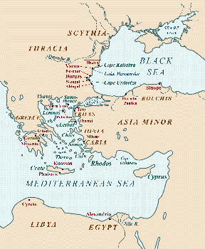 umber of significant civilizations, originating
and developing on its coast and in the immediate hinterland. umber of significant civilizations, originating
and developing on its coast and in the immediate hinterland.
Due to
environmental changes, much of what remains of these coastal civilizations
is now under water. Materials found on the sea floor raise a number of questions
about the history of the western Black Sea coast, and its relations with
the Mediterranean. This paper addresses some of these questions for the first
time, and discusses a number of new sites found through underwater archaeology
(figs.1,2).
Fig.1: Map of sites mentioned in text from the Black Sea and
Mediterranean regions.
There are three basic fields in the history of coastal civilization, which
can probably best be studied by analyzing the results of underwater
archaeological surveys:
1. Changes in the level of the Black Sea and related environmental changes
along the coastal strip during the last 6-7 millennia;
2. The types and extent of prehistoric, ancient, and Medieval navigation
along the western shore of the Black Sea, and the contacts between these
populations and contemporary peoples in the eastern Mediterranean;
3. The coastal harbor system, including harbor locations, harbor constructions,
and submerged parts of old settlements.
In this article, two main topics will be discussed. The first is the
reconstruction of settlements along the Black Sea coast in the Final Neolithic
Era (Eneolithic) and Bronze Age, on the basis of data from underwater
archaeological research. The second concerns specific research methods used
in studying submerged Eneolithic and Bronze Age sites. Consistent site
methodology, if carefully followed in accordance with the given types of
underwater sites, should yield a greater amount of information. It should
also permit the investigators to place their findings in a useful chronological
and comparative historical context.
Archaeological research along the Bulgarian Black Sea coast has revealed
many finds from submerged and partly submerged settlements, harbors and harbor
facilities, and shipwrecks (Stanimirov 2003). This paper will focus primarily
on discoveries dated to the 3rd-2nd millennium BC, including Eneolithic and
Bronze Age settlements that are now submerged. These findings raise questions
about the first contacts between the western Black Sea and the Mediterranean
world, and also provide evidence to support the following premises:
1. Mediterranean ships sailed the Black Sea for the first time in the 16th
c. BC. After this point, the population of the western Black Sea maintained
trade contacts with the populations of the eastern Mediterranean, including
the Achaeans, Trojans, and Cretans in the 16th-12th c. BC, and the Carians
in the 12th-11th c. BC.
2. Due to mutual or complementary material needs, trading networks were
established. Present data is insufficient to define the intensity of trade
relations, as to whether at any given time it was decreasing, increasing,
or temporarily inactive. In some regions, trade was probably very active.
3. Metals - copper, tin (both components of bronze), and eventually, iron
and lead - were important as exports and imports.
Archaeological evidence allowing the reconstruction of settlements along
the shores of the western Black Sea (and supporting the above premises) can
be divided into three groups: submerged settlements; submerged harbor sites
and systems, including anchors and anchor material; and remains of cargo
and ships, the former including metal objects and amphorae, the latter including
only a few smaller vessels in the Bronze Age.
Submerged Settlements: Surveys along the western Black Sea shoreline have
led to the discovery of 10 submerged Eneolithic
settlements, and at least 29 sites dating from the Bronze Age (fig.2). Most
settlements that began their existence in the Late Eneolithic continued into
the Bronze Age.
The submergence of the settlements probably resulted from variations in sea
level caused by the weight of glacier movements deforming the earth’s
crust. These variations, in turn, were caused by climatic instability, including
warm/cold spells that led to glacial melting and sea level ri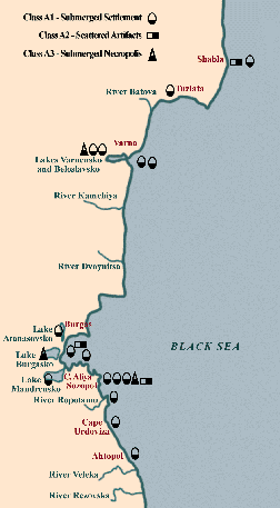 se, or to ice
accumulation and sea level fall. se, or to ice
accumulation and sea level fall.
During the Early and Middle Holocene, warmer periods led to the gradual
submergence of the western Black Sea coast. At the end of the 5th millennium
BC, the so-called New Black Sea Transgression caused the water to overflow
parts of the mainland. During its second stage (mid-4th millennium BC) a
2-meter drop in sea level occurred.
During the Eneolithic Age (ca. 3500-2500 BC), such climatic changes led to
the formation of a new shoreline, and thus to the populating of coastal and
harbor settlements. These dynamic coastal processes help explain the high
number of submerged settlements (fig.2) dating from the final period of the
Eneolithic. At least ten settlements are recorded, a concentration suggesting
a Late Eneolithic settlement base along the western Black Sea coast, which
continued into the Bronze Age.
Fig.2: Submerged settlements along the Bulgarian Black Sea coast
(S. Stanimirov).
At the end of the Early Bronze Age and in the Middle Bronze Age, a new sea
level rise began, which destroyed the settlements built on the first overflowed
terrace, and turned the rivers’ mouths into gulfs. This elevation in
sea level lasted until the end of the 2nd millennium BC or the beginning
of the 1st millennium BC, after which the so-called Fanagorian Regression
lowered sea level by 3-4 m. After the end of the 5th c. BC, the Second Wallachian
Transgression began, which continues to the present to raise sea levels 1.4
- 4.4 mm/year. Since the 5th c. BC, the sea level has risen some 9.40 m.
All sites from the Late Eneolithic and Bronze Age on the western Black Sea
coast have consistent settlement features and artifacts, including house
posts, ceramics (fig.3), flint tools, cult objects (fig.4), and other materials.
These finds provide evidence for the submergence of the settlements soon
after they were abandoned. The depth of submergence does not exceed 9-10
m, indicating that the sea level rose by about 10 m (Porojanov 1999).
A total of five Bronze Age settlements have been examined by archaeological
excavations. These include the settlement near Cape Urdoviza; the settlement
near modern Sozopol, called Apollonia in ancient times; the settlement of
Arsenala at Lake Varnensko near Varna; the ancient port of Odessos (Varna);
and the settlement near the mouth of the Ropotamo River. Some notable, culturally
revealing Eneolithic and Bronze Age findings from these sites will be briefly
summarized here, prior to a more detailed discussion on underwater methods
and other typical findings including anchors and shipwrecks. Cape Urdoviza: The Bronze Age settlement near Cape Urdoviza is situated about
60 km from Burgas, on the southern part of the Black Sea shore. Although
it has not been thoroughly examined, the information gained so far is
interesting. Houses at the settlement were made of wattle plastered with
clay, and well-preserved pottery vessels, including pitchers, have been recovered
(fig.3).
Faunal analysis
has revealed that in this Balkan region, the most common animal species found
were turros (Bos primigenius), bear, and wolf. Overall, more than 7,000 animal
remains have been unearthed at Cape Urdoviza, representing more than 32 species
of animals, birds, reptiles, and mollusks. From these remains, about 15 wild
and 6 domestic animal varieties have been identified, including f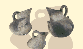 oxes, wolves,
badgers, wild-cats, wild boars, brown bears, wild oxen, red deer, roe deer,
rock martens, and various birds. Analysis of horns has revealed a few hybrids of domestic and wild cattle. This evidence allows us to conclude that by
the Bronze Age, the active domestication of wild cattle had already been
in practice for some time on this part of the Black Sea coast. oxes, wolves,
badgers, wild-cats, wild boars, brown bears, wild oxen, red deer, roe deer,
rock martens, and various birds. Analysis of horns has revealed a few hybrids of domestic and wild cattle. This evidence allows us to conclude that by
the Bronze Age, the active domestication of wild cattle had already been
in practice for some time on this part of the Black Sea coast.
Fig.3: Pottery from the Early Bronze Age settlement near Cape Urdoviza
(photo: S. Stanimirov).
Of particular interest is the enormous concentration of cult items: 5 parts
of buffalo horns, over 40 horse skulls, 2 clay female statuettes, and 2 stone
casts for metal hammers. This suggests the existence of a cult center or
a temple, analogous to those in Asia Minor. For example, the cult of the
horse on the Balkan Peninsula already existed by the Late Eneolithic.
According to both dendrochronological and carbon-14 analyses, the Cape Urdoviza
settlement existed for about one and a half centuries, from the middle of
the 29th c. BC to the end of the 28th c. BC. The recorded dendrochronological
samples are as follows: 10 samples from 2850-2778 BC; 60 samples from 2778-2737
BC; and 3 samples from 2737-2725 BC. Precious items found at the site indicate
that the settlement was probably abandoned suddenly (Porojanov 1999; Ribarov
1991). Stone anchors were also found here.
Sozopol: The port of Sozopol has produced submerged settlements from both
the Late Eneolithic and Early Bronze Age periods. The Eneolithic settlement
has a clearly outlined cultural layer marked by a fire that devastated the
settlement, and whose marks were submerged by the New Black Sea Transgression.
The site yielded house remains containing wooden framing posts, flint tools,
and anthropomorphic figurines. Sozopol’s Eneolithic ceramics belong
to the final stage of the Varna Culture, similar to pottery from other Late
Eneolithic cultural complexes of Kodjadermen-Gumelnica- Karanova VI, and
Krivodol-Salkuca-Balbii.
Materials found in the harbor system from the subsequent, Early Bronze Age
settlement at Sozopol included pottery types comparable to those of settlements
in Asia Minor, and the associated islands of Lemnos, Lesbos, and Samothrace
(fig.1). Also found in Early Bronze Age deposits were house posts, faunal
remains, and stone anchors.
Arsenala at Lake Varnensko, near Varna: Pottery from the Late Eneolithic
settlement of Arsenala includes complex, decorated vases from the Varna Culture.
In layers representing the hiatus between the Eneolithic Period and Early
Bronze Age were found wooden posts from house remains, bone and stone tools,
and ceramic fragments. Early Bronze Age cult items from Arsenala include
female and male figurines
(fig.4).
Ropotamo River mouth: This submerged settlement contained Early Bronze Age
ceramics, parts of houses with remains of post construction, and faunal remains.
Ship-related artifacts include stone anchors (an important artifact class,
discussed below in detail).
Methodology of Underwater Surveys: To examine submerged settlements successfully,
it is important to apply current research methods. In order to locate the
settlements, spatial and geophysical methods ar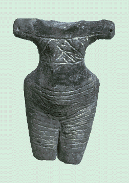 e used, which, by means of
detecting magnetic anomalies, delineate the limits of the submerged settlement. e used, which, by means of
detecting magnetic anomalies, delineate the limits of the submerged settlement.
Magnetometer survey: Proton magnetometer readings are widely used along the
Bulgarian Black Sea coast, both to search for new underwater sites, and to
localize already discovered sites. Such research has been done at the mouth
of the Ropotamo River, near Cape Urdoviza, near Kaliakra, and in other places
(Georgiev et al. 1991). The methodology of research using a magnetometer
includes the following:
Fig.4: Early Bronze Age figurine from the settlement of Arsenala,
at Lake Varnensko (photo: S. Stanimirov).
1. Geodetic preparatory work: This consists of two stages: a) the positioning
of a local coordinate grid; and b) selecting points of reference from which
measurements will be made.
2. Measurements: A proton magnetometer is towed by a vessel above the area
under examination. The value of the magnetic field is recorded, and measurements
are taken every 10 seconds. The vessel towing the magnetometer moves in corridors
above the examined area, outlined beforehand.
3. Processing the results after the entire area is surveyed: The values of
the magnetic field are compared for differences, termed magnetic anomalies.
The existence of such anomalies may suggest that the magnetic field of the
sea bottom is disrupted by an object, possibly an archaeological structure.
4. Analyzing the results: The anomalies are checked with a metal detector
to eliminate those not part of an ancient archaeological structure.
5. Checking the anomalies: Testing is done by underwater excavations in order
to define the essential features of the localized object.
Strict adherence to these procedures is necessary for high efficiency in
the use of the magnetic method.
The geophysical methods used along the Bulgarian Black Sea coast allow the
localization of archaeological objects at places difficult for scuba divers
or an unmanned apparatus to inspect. Their main advantage is the great amount
of information that can be gathered. They are useful not only for localizing
underwater archaeological sites, but also, through complex analysis of sonograms,
profilograms, bathymetry, and magnetic mapping, enable the reconstruction
of paleorelief (Georgiev 1994). This includes the use of side-scan sonar,
which “takes a picture” of the sea bottom, where sandy, rocky,
partly-covered finds are located; the sub-bottom profiler, which penetrates
the bottom sediments and defines their character and composition; the echograph,
which defines depth and is used for making a bathymetric map of the bottom
(Nenov 1991; Tasev 1994); and the magnetometer, which develops a geological
map of different rock types, and also aids in further discovery of submerged
constructions.
Underwater excavation methods: Excavations are the second stage of underwater
archaeology. During this process, much interesting information is gathered
and must be recorded. In the examination of submerged settlements along the
Bulgarian Black Sea coast, two types of records are kept: manual and electronic.
Manual record-keeping includes recording forms or preliminary prepared sheets
listing concrete characteristics of the submerged settlements. For example,
the form used in documenting underwater research near the Arsenala settlement
included the following information:
1. Position: site name and coordinates;
2. Description: color, shape, size;
3. Records of samples for field, dendrochronological, and other types of
analyses;
4. Description of any recovered objects, i.e. wooden posts; weapons; anchors.
(Specific requirements for recording these materials include size, outer
features, etc.);
5. Plan, drawing, and scheme of the site;
6. Diving information: the name of the scuba diver, the time spent under
water, depth, and other conditions.
Electronic recording is done with a camera or a video camera. These records
eliminate the disadvantages of other types of record-keeping, including drawings
and schematic sketches. Recording under water does not differ much from the
requirements for archaeological recording on land, yet it is even more demanding,
since the working conditions are always changing.
Part of the recording involves the positioning of a local topographic grid,
which will guarantee precise inclusion of each find in the archaeological
complex, as well as all relations between the finds in the complex. This
is done by using a plan-square net. In the archaeological excavations of
the settlements near Sozopol and Urdoviza, the plan-square net was constructed
on the shore from metal tubes. It was made up of 5 x 5 m squares lowered
into the water above the excavation site. The placing of the net is often
difficult and time-consuming. Once positioned on the bottom, it tends to
move, which can result in inaccurate records. The movement of the net is
more common when the bottom is excessively soft or slimy. In spite of these
obstacles, the plan-square net is always applied in underwater archaeological
research along the Bulgarian Black Sea coast.
Excavations, the final stage of archaeological field research, are preceded
by coring and the taking of samples. The aim of the coring is to analyze
the layers or structures below the surface. Core samples were taken during
examination of the settlement near Urdoviza to establish the width and depth
of the “buried” objects. Stratigraphic, dendrochronological, and
palynological samples were taken to help analyze the archaeological remains.
Such samples are routinely obtained for all submerged settlements in order
to determine their date.
After the limits of the submerged settlement are outlined, once it is precisely
dated with the help of core sample research, and once other samples have
been taken, the underwater archaeological excavations can commence. Differing
methods of exavation may be used in order to obtain satisfactory results.
During the excavation, principles of stratigraphy are followed (just as on
dry land). After the upper layers are examined, they are removed. This is
done with the help of various instruments. In the research process of the
settlements near Sozopol, Urdoviza, the Ropotamo River, and Arsenala, an
ejector was used. It “swallows” the deposits and the already excavated
and examined layers. The ejector is held at approximately 30 cm above the
excavated layer, in order for the diver-archaeologist to watch and control
what is being swallowed into the tube. No matter how the tube is controlled
and how good the visibility is, some small objects can easily be missed.
In order to prevent these materials from being thrown away, the ejector has
a filter positioned at the end of the tube. In a few cases, pieces of ceramics
and parts of posts have been discovered during the examinations of the
above-mentioned settlements. During the removal of the deposits, some objects
need to be taken out of the water and placed on the shore, a process that
varies considerably, depending on the specific materials being removed.
The objects discovered in the settlements are put in non-salinated water.
This includes ceramics, stone or lead anchors, parts of wood, as well as
different organic substances. Afterwards, the objects are transported to
the regional museum, where they are conserved and restored under laboratory
conditions.
Underwater survey methods: While systematic archaeological research is applied
in the examination of submerged settlements, some materials are normally
found on the surface of the harbor bottom, without stratigraphic context.
For example, only a small percentage of anchors are found during archaeological
excavations. Such was the case in anchors discovered in the harbors of Sozopol,
Nesebar, Kaliakra, Pomorie, Urdoviza, and other sites, almost none of which
were discovered in stratified contexts. Thus, underwater methods at these
sites are focused on methods of archaeological survey or reconnaissance.
These can be divided into two major types: one based on the human eye and
manual equipment, and the second on electronic technologies.
Perhaps the most basic principle in underwater survey research, regardless
of the method employed, is that the position of the diver must be known at
any moment. This allows the most efficient use of time, and increases the
quality of recorded information. Equally important in governing the effectiveness
of a scuba-diving search involving the visual examination of a harbor is
the degree of visibility. Thus, it is critical that these methods be applied
in areas with shallow depth and relatively good visibility. The most commonly
used method for controlling the position of divers in underwater reconnaissance
is known as swimline. In this method, corridor outlines, or transects, are
set for the divers to swim along, thus making the direction of their motion
known. The length of the corridors depends on the size of a given area, while
the width depends on the conditions of visibility - the shorter the visibility
distance, the narrower the corridor. For example, in the research of the
harbor near Kaliakra, the corridors were 20 m wide and 150 m long. These
corridors were marked on the surface by buoys. In each corridor were four
divers, one of whom determined the direction of motion with the help of a
compass. The other three divers follow him and mark all finds with buoys.
These buoys are detected by geodetists on the shore and are plotted on a
map. In this way, a plan of the discovered objects is made and it is possible
to define the limits of their distribution (Toncheva 1964). Using these methods,
a large number of stone anchors and stocks - both stone and lead, spanning
the Bronze Age through Byzantine period - have been discovered.
In general, in the underwater archaeological research of submerged settlements
along the Bulgarian Black Sea coast, every effort is made to apply an
interdisciplinary approach. The joint use of different research methods improves
the quality and range of the information gathered, whose analysis may lead
to the more accurate reconstruction of settled life along the shores. A great
amount of archaeological material has been discovered as a result of adhering
to the research procedures outlined here for underwater archaeology. To these
should be added finds discovered either accidentally (e.g., anchors) or during
construction works. Both surface finds and those discovered during construction
projects aid in quantitative analysis of overall finds, such as the typology
of the pottery forms, diversity in faunal assemblages, or the range of anchor
forms and materials.
The resulting large collections of pottery, lithics, parts of wooden house
posts, precious cult objects including figurines, a variety of animal bones,
and other objects are all analyzed and compared, in their typology and
chronology, with similar finds from settlements in the eastern Mediterranean.
This allows many significant inferences to be drawn concerning settlements
along the Bulgarian Black Sea coast in the Bronze Age.
Importantly, as table 4 indicates, the types of artifacts discovered during
archaeological research and construction works have basically been the same.
The difference is that systematic research allows everything to be recorded
in a specific order, thus making it possible to define stratigraphy, the
sequence in which the dwellings were made, and reasons for their submergence.
Regional comparisons: The many settlements from the Early Bronze Age along
the Bulgarian Black Sea coast were not isolated. They are contemporary with
Early Bronze Age settlements and cultures from northwestern Asia Minor, as
well as island settlements such as Poliochni on Lemnos, Termi on Lesbos,
Palatiali Astakos on the Ionic coast, and Micro Vuno on Samothrace. A widespread
community of maritime cultures seems to have existed by the Early Bronze
Age along the western coast of the Black Sea, in the northern and central
Aegean region, and probably also around the Sea of Marmora. This civilization,
located along the coast of southeastern Europe, northwestern Asia Minor,
and the islands, probably perished as a result of paleoclimatic and sea-level
variations (Porojanov 1999).
Submerged Harbor Sites and Systems: The initial Neolithic settlements along
the western Black Sea coast grew into harbor centers, in which active
cultural-economic relations were established between the local Thracian
population and the Mediterranean world. Our findings make it clear that the
first active contacts between these two cultural-historical societies were
established in the Bronze Age. These contacts were largely maintained by
water. One group of finds, anchors and related materials, testifies to this
abundance of water contacts.
Anchors and anchor materials: Anchors make up a highly important class of
maritime artifact that indicates the presence of harbors, and shows consistent
correlations of form, material, and chronology. While normally found as surface
or accidental finds, a detailed examination of anchors allows us to determine
when the harbor system was built. The earliest evidence of western Black
Sea harbors is provided by stone anchors (fig.5). These consist of a flat
stone (either smoothly or roughly shaped) in which one, two, three, or, rarely,
four holes were bored. Wooden stakes were driven into these holes, whose
sharpened ends were hung, driven, or dug into the stony or sandy sea-bottom.
The weight of these early anchors varies from a few dozen to a few hundred
kilograms. The weight depended, of course, on the size of the vessel on which
they were used.
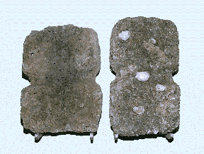
Fig.5: Stone anchors without holes, from Nesebar; 16th-12th c. BC
(photo: S. Stanimirov).
Since stone anchors are found in close proximity to settlements, analysis
of the anchors has helped to prove the existence of early navigation in the
western Black Sea and to answer questions about the early harbor system.
Over 300 stone anchors have so far been discovered. Since their archaeological
context is unclear, their dating is complicated. The survey of the settlements
in the Sozopol harbor and at Urdoviza Cape dating from the Early Bronze Age
conveys some important information about the ages of the anchors. Because
these settlements are found on the sea bottom, or anchorage level of stone
anchors, it logically follows that the anchors were used after the settlements
had been submerged (Porojanov 1999a). This takes the anchors’ usage
back to the 2nd millennium BC.
The division of the anchors into three groups according to depth provides
an interesting chronological perspective. Group 1, ranging in depth from
5-11 m, has six find spots, with the greatest total number of anchors found,
indicating that their most active use came at the end of the 2nd millennium
BC (i.e. the period after the Early Bronze Age settlements were submerged;
Porojanov 1999a). Group 2, with six find spots, has anchors with a depth
greater than 11 m. Group 2 possibly dates to the late 3rd-4th millennium
BC, i.e. earlier than group 1. Group 3 has four find spots on the shore,
or in the shallow waters of about 3 m depth, with the smallest number of
anchors found here - about 10. Group 3 probably dates to a later period,
about the middle of the 1st millennium BC.
For the exact dating of anchors, however, more evidence is needed, and similar
stone anchors discovered throughout
the Mediterranean
are useful for comparison. The anchors from the eastern Mediterranean date
as far back as the 3rd-2nd millennium BC. Most agreement among scholars centers
on anchors dating to the second millennium, including the period of the
16th-11th/10th c. BC [J. Bass:14th-12th c. BC (Bass 1972); H. Frost: 14th-12th
c. BC (Porojanov and Popov 1982); M. Lazarov: the same period (Lasarov 1975);
G. Toncheva: 14th-10th c. BC (Toncheva 1973); B. Dimitrov:16th-12th c. BC
(Dimitrov and Stoichev1976)].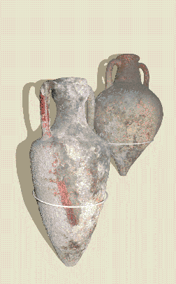
An interesting find that sheds some light upon the dating of stone anchors
is a metal ingot discovered near Kaliakra together with a stone anchor. The
metal ingot is in the form of a stretched ox hide and is dated to the Late
Bronze Age, 14th-12th c. BC (Toncheva 1981).
It is thought that the ships of the Aegean civilization from the 2nd millennium
BC had stone anchors (Porozhanov 1999a). Thus, the location, the depths at
which the anchors are found, and the archaeological parallels and similarities
to the eastern Mediterranean help date the stone anchors of the western Black
Sea to the 3rd-2nd millennium BC, with their most active use in the Late
Bronze Age period of the 16th-12th c. BC (Porojanov 1989).
Fig.6: Ancient amphorae from Sozopol, imported from the eastern
Mediterranean (5th-4th c. BC) (photo: S. Stanimirov).
The large number of stone anchors raises the question of why such a big fleet
was needed along the western Black Sea coast. Petrographic analysis of the
anchors shows that about 90% of them were made of native stone, and 10% of
foreign materials. The local stones of which they were made find exact matches
along the western Black Sea coast. We could even outline two regions of
anchor-making: one in the north, between Cape Kaliakra and Cape Shabla, and
the other in the south, between Nesebar and Tzarevo. We could also speak
of an anchor workshop near Ahtopol, where a cluster of unfinished anchors
was discovered. Certainly, this was a local workshop, using local materials
serving local ships (Ivanov et al. 1985).
Once the age and origin of the stone anchors have been defined, we can conclude
that along the Bulgarian Black Sea coast there was navigation preceding the
time of Greek colonization. Ships steered by the ancient Thracians were quayed
in a built harbor. This points to trade, and to certain organized relations
with the eastern Mediterranean. At the center of that trade were metals.
Specifically, the export of metals, including Thracian copper, explains the
great number of stone anchors found in the western Black Sea harbors,
particularly from the second half of the 2nd millennium BC. Their use also
continued through antiquity until the middle of the 1st millennium BC. The
existence of such an intensive trade between ancient Thrace and Mediterranean
lands suggests the existence of a constructed harbor system related to the
numerous Thracian settlements along the seashore. That harbor system, localized
by the anchor-cluster, was also preserved after the Greek colonization.
Anchor material dating to the 3rd-2nd millennia BC shows that this is the
earliest harbor system along the western Black Sea coast. There is no doubt
that active trade existed in those harbor centers.
Trade Cargo and Ships: Two main types of cargo or goods traded by ship will
be considered: 1) metals; and 2) other goods requiring storage vessels, including
amphorae.
Metals in early maritime commerce: The 3rd-2nd millennium BC is the period
of the Bronze Age for the Thracian lands. In the 3rd millennium BC arsenious
bronze was used, and the production of real bronze, an alloy of copper and
tin, began in the 2nd millennium BC. The principal ingredient in bronze
production is copper. Although bronze was not widely used in the manufacture
of tools in the 3rd millennium BC, it was highly precious. During the 2nd
millennium BC, and especially after the 16th c. BC, the production of real
bronze was improved, which led to its use in tool-making and, more importantly,
in the manufacture of weapons. In this age, both the horse-drawn chariot
and the double-edged sword were developed - inventions enabled by the production
of real bronze. The use of bronze gradually increased over these two millennia,
and reached its height in the Late Bronze Age - the 16th/15th - 12th/11th
c. BC. Out of bronze are made both sickles and swords!
It is evident that the most important metal of the 3rd-2nd millennium BC
was copper. In the ancient Thracian lands, copper was mined as early as the
Eneolithic Age. Furthermore, in the 4th millennium BC, Thrace was the first
and most active metallurgical center, not only in Europe, but in the whole
world. (Porojanov1989a). From there copper spread north and south. In the
2nd millennium BC, however, tin was needed for the production of bronze,
but was not available in ancient Thrace, and had to be imported. The presence
of local bronze articles unequivocally shows that such trade was conducted,
with copper exported to the lands where it was scarce, and tin imported from
the lands where it was mined. Two metal ingots from the Bulgarian Black Sea
coast testify to such trade: one of copper, found near the village of Cherkovo,
Burgas, and another of gold, found in the gulf by Cape Kaliakra. Such finds
are discovered at the harbor of Cape Kaliakra (Toncheva 1973), near the village
of Cherkovo, Burgas, as well as in the gulf by the village of Varvara near
Ahtopol and in the aquatoria of Sozopol (Stanimirov 2003).
The two nearest known tin deposits are in Central Europe and in the eastern
lands of Asia Minor (Porojanov 1989). Probably, the importation of tin was
conducted along the Danube River, although it may have come through eastern
Mediterranean insular and continental harbor intermediaries. Regular trade
contacts were established in all these directions.
At the end of
the 2nd millennium BC, the Early Iron Age began in southeastern Europe. Instead
of tin and bronze, tools and weapons began to be widely made of a new metal,
iron, which is much harder and more robust. Also, while copper and tin are
hard to find, iron ores could be found where copper practically no longer
existed. In practice, copper turned out to be unnecessary, because Thrace
is rich in iron ore deposits. This did not, however, end the trade contacts
between the western Black Sea coast and the eastern Mediterranean world.
Other trade goods: Unlike the numerous stone anchors found from the 15th-12th
c. BC, testifying to active navigation between these two cultural areas,
there is an absence of archaeological materials (including storage and transport
vessels) to i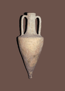 ndicate exchanged goods from the same period. Yet ancient authors
describe the exporting of cereals, wood, charcoal, salted fish, and furs,
as well as the importation of wine and olive oil. These goods, extensively
produced in the eastern Mediterranean world, are the same seen in subsequent
periods. Few traces of amphorae remain from before the 1st millennium BC,
although many examples have been unearthed from the Graeco-Roman Era (figs.6-7).
The absence of amphoric tare in the Late Bronze Age cannot be used as an
argument against the existence of trade. Indeed, the amphora was not devised
until later, in the 7th c. BC. A large amount of amphoric tare (figs.6-7)
thus appears in the cargoes of shipwrecks dating from after the Greek
colonization. ndicate exchanged goods from the same period. Yet ancient authors
describe the exporting of cereals, wood, charcoal, salted fish, and furs,
as well as the importation of wine and olive oil. These goods, extensively
produced in the eastern Mediterranean world, are the same seen in subsequent
periods. Few traces of amphorae remain from before the 1st millennium BC,
although many examples have been unearthed from the Graeco-Roman Era (figs.6-7).
The absence of amphoric tare in the Late Bronze Age cannot be used as an
argument against the existence of trade. Indeed, the amphora was not devised
until later, in the 7th c. BC. A large amount of amphoric tare (figs.6-7)
thus appears in the cargoes of shipwrecks dating from after the Greek
colonization.
Fig.7: Ancient amphorae from Nesebar (476-454 BC), imported from
Chios Island (photo: S. Stanimirov).
While some Bronze Age goods may have been transported in amphorae, wine was
probably shipped in pithoi during the Creto-Mycenaean era (ca. 2000-1200
BC). Creto-Mycenaean luxury ceramics are also lacking in the western Black
Sea. Yet such negative evidence does not itself preclude the existence of
active Bronze Age contacts between the eastern Mediterranean lands and the
western Black Sea coast. By analogy with a much later period, while neither
utilitarian nor luxury Venetian ceramics from the 13th-14th c. AD have ever
been found along the Bulgarian Black Sea coast, active trade relations between
the Bulgarian shore and the Italian sea republics definitely occurred in
that period. The lack of ceramic evidence in this case is due to the fact
that goods were transported in sacks and kegs, and local ceramics were not
objects of exchange.
Shipwrecks: Along the Bulgarian Black Sea coast, the remains of vessels from
the Bronze Age have been discovered, but these are small boats, more indicative
of local navigation than of contacts between the Black Sea and the Mediterranean
world. In spite of this, they aid in the reconstruction of settled life during
this period. Examples are three dugout boats dated to the Bronze Age. Although
discovered at different places, they allow us to trace a process of development
and improvement in boat construction. Such vessels have been discovered in
Boaza and around Topoli Station, both near Lake Varnensko, and in the swamp
near the village of Skala, Burgas (Todorov 1981; Mihailov 1984).
In the Boaza district four boat fragments were found, with an average length
of 3.5 m and width of 0.48 m. In form these resemble extended troughs, and
were probably used for shorter passages across the water basins. They date
from the Early Bronze Age, and may also be related to the population inhabiting
the nearby settlement at Boaza during the same period.
In the swamp near the village of Skala, Burgas, a similar boat made of oak
was found, but with a length of 2.28 m and width of 0.54 m. Probably in this
case, too, it can be associated with one of the settlements dating to the
Early Bronze Age.
The third boat comes from the region of Topoli Station on Lake Varnensko
(fig.8). It is 3.15 m long and 0.52 m wide and carved out of a blagunus (oak)
trunk. This vessel shows a change in construction, for there is a slight
trace of a keel part. The inside is divided into sectors, or spanhouts; two
parts of the trunk are preserved. These both support the boards and functio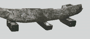 n
as cross-ribs. The well-defined oval forms of the bow and the stern facilitated
movement. These traits reveal that the boat’s construction was not
anomalous, but rested upon established construction traditions. The boat
may come from a Bronze Age settlement on Lake
Varnensko. n
as cross-ribs. The well-defined oval forms of the bow and the stern facilitated
movement. These traits reveal that the boat’s construction was not
anomalous, but rested upon established construction traditions. The boat
may come from a Bronze Age settlement on Lake
Varnensko.
Fig.8: Early Bronze Age dugout boat from Topoli Station, Lake Varnensko
(photo: S. Stanimirov). In Bulgarian archaeology, there has been an attempt to see models of Early
Bronze Age ships in some of the clay vessels found in Ezerovo II near Lake
Varnensko (Toncheva 1981). These elongated plates are not sufficiently convincing
evidence, and we should wait patiently until a real model is discovered,
or better still, an Early Bronze Age ship from Thrace. The bones of dolphins
and of belted bonito, discovered during excavation of the Early Bronze Age
settlement near Urdoviza, serve as indirect evidence of the use of navigation
vessels for fishing (Porojanov 1991), because dolphins and belted bonito
can be caught only by means of boats and ships. We may also assume the existence
of ships for overseas contacts.
Evidence is considerably more abundant for the 2nd millennium BC, and especially
for its second half. The absence of actual ship remains is compensated for
by a number of equally important archaeological materials: namely, stone
anchors, dating mainly from the second half of the 2nd millennium BC. Their
weight at times reaches several hundred kilograms - a fact that establishes
the size of the vessel. Based on petrographic analysis of the anchors (Ivanov
et al. 1985), which proves their local origin, it is evident that the ancient
Thracians were in contact with the Mediterranean lands by means of their
own ships. We do not know what they looked like, but probably they had features
in common with Phoenician and Cretan ships, whose types were known to the
Thracians.
The Thracians in the Late Bronze Age used oar-driven ships to navigate the
ocean, similar to the Late Bronze Age vessels found near Cape Gelidonya and
Cape Cos on the western coast of Asia Minor. Sail-driven ships would not
appear until the early Iron Age, around the 7th c. BC. Oar-driven and sail-driven
ships used different types of anchors. The former used stone anchors, while
the latter used wooden anchors with stone and lead stocks.
The introduction of the wooden anchor with stock in the 7th c. BC (Early
Iron Age) coincides chronologically with the Greek settlement along the Thracian
part of the Black Sea shores. The Thracian colonists employed wooden anchors
aboard their recently developed wind- or sail-driven ships.
Studying the distribution of stocks along the Black Sea coast helps to illuminate
Thracian use of both galleys and sail-driven ships in the Early Iron Age.
While the stone anchors are clustered closer to the shore, where boats would
have been safe from contrary winds, the wooden anchors with stone and leaden
stocks are clustered where the harbors are open to the winds. Thus, stone
anchors probably served on galleys (rowing ships), while the stone and leaden
stock type are connected with sailing ships. Galleys rowed from the harbor
would have transported goods to sailing ships stationed in areas of higher
wind.
For two millennia, the Thracians navigated the waters of the Black Sea, the
Sea of Marmora, and the Aegean Sea. Thracian civilization was in widespread
contact with peoples in the rest of the Mediterranean world.
The trading partners of the Thracians were the Cretans, the Achaeans, and
the Carians. By the 2nd millennium BC, the Thracians had already established
an extensive trading network within the Black Sea region. They most often
exported metals, and imported major commodities such as wine and olives.The
presence of metal ingots found in the harbors provides further evidence of
metal import and export, an issue already discussed.
In conclusion, Bronze Age water transport was of paramount importance for
establishing trade relations that continued through the Classical era. Despite
temporary lulls in trade resulting from such factors as military and political
unrest, trading maintained economic equilibrium throughout the eastern
Mediterranean lands for many centuries. During the Greek and Hellenistic
periods, at western Black Sea markets imported goods came from Miletos, Heraclia
Pontica, and from the islands of Chios, Rhodes, Cos, Thasos, and, during
the Roman Age, from Sinope. Also, wine, olive-oil, and clay lamps came from
Egypt, Athens, and Corinth, and glass came from Syria and Asia Minor. Goods
entered the interior of ancient Thrace via the road network along the Black
Sea coast. Later on, Thrace became a Roman province and, after that, part
of Bulgaria.
In this article, we have surveyed the kinds of sites and objects found through
underwater archaeology along the Bulgarian Black Sea coast dated to the
Eneolithic period and Bronze Age: submerged settlements, anchors and anchor
materials, and remains of vessels and their cargoes. Also presented were
the relevant methods of underwater research for each type of find, and the
specific problems of each. On the basis of these findings, the settlement
life on the western shores of the Black Sea has been reconstructed for these
early periods. It can be deduced that the Black Sea region had turned into
an inseparable part of the eastern Mediterranean world by the Bronze Age.
References:
Bibliography on Black Sea Coast: Bass, J. 1972. “Les premiers navigateurs en Mediterranée et au Proche-Orient.” In Archéologie sous-marine (4000 ans d`histoire maritime), p.176, Paris. Dimitrov, B. and K. Stoichev. 1976. “Kamenni kotvo ot Sozopolskia zaliv.” Vekove 1: 61-66. Frost,
H. See Porojanov, K. and V. Popov. 1982. “Les recherches archéologiques
sous-marines conduites pour le centre d’histoire maritime et
d`archéologie sous-marin a Sosopol.” In Thracia Pontica I, 1er symposium international a Sozopol, pp.311-315. Georgiev,
M., A. Petrov, N. Nenov, D. Georgiev, and C. Angelova. 1991.
“Prospecting of Underwater Archaeological Sites Using Geophysical
Methods.” In Thracia Pontica IV, Quatričme symposium international a Sozopol, pp.451-470. Georgiev,
M., A. Petrov, D. Stoev, and K. Velkovski. 1994. “Geophysical
Prospecting of the Aquatoria of the Southern Black Sea Coast Aimed at
Reconstruction of Paleorelief.” In Thracia Pontica V, Cinquičme symposium international a Sozopol, pp.317-328. Ivanov,
J., D. Dimov, H. Pimpirev, and H. Kuneva. 1985. “Les résultats
preliminaires de l’analyse petrographique des ancres en pierre et de
jas du littoral bulgare de la Mer Noir.” In Thracia Pontica II, 2eme symposium international a Sozopol, pp.135-150. Kapiten, G. 1986. “Graeco-Thracian Wood-Anchors.” In Thracia Pontica III, 3čme symposium international a Sozopol, pp.381-394. Lasarov, M. 1975. “Localités presgreques sur la cote de la Mer Noir au Sud du Balkan.” Thracia 3: 112-113. Mihailov, A. 1984. “Izsledvane I podobriavane na metodite I sredstvata za konservatzia na raheologicheska darvesina.” In Suhai Vlazhna, Sofia. Nenov, N. 1991. “Side-scan Sonar and Sub-bottom Profilers in Underwater Archaeology.” In Thracia Pontica IV, Quatričme symposium international a Sozopol, pp.471-476. Porojanov, K. 1989 “Datirovka na kamennite kotvi s otvori po Balgarskoto Chernomorie - problemi I postijenia.” In Archeologia 1: 6-13. Porojanov, K. 1989. “Problems of the Thracian Socioeconomic and Political System (second half of the 2nd millennium BC).” In Etudes Balcaniques 1. Porojanov, K. 1991. “Le site submergé D’Ourdoviza.” In Thracia Pontica IV, Quatričme symposium international a Sozopol, pp.109-112. Porojanov, K. 1999. “The Submerged Western Pontic Civilization in the 3rd Millennium BC.” Thracia 12: 15-21. Porojanov, K. 1999. “The Ancient Stone Anchors from the Bulgarian Black Sea coast.” In Tropis V, 5th International Symposium on Ship Construction in Antiquity, Nauplia, 1993, pp.329-336, Athens. Ribarov, G. 1991. “The Osteological Material from the Sunken Settlement at Urdoviza.” In Thracia Pontica IV, Quatričme symposium international a Sozopol, pp.113-118. Stanimirov,
S. 2003. “Underwater Archaeological Sites from the Ancient and Middle
Ages along the Bulgarian Black Sea Coast - Classification.” Archaelogica Bulgarica 1: 1-34. Tasev, V. 1994. “Side-scan Sonars.” In Thracia Pontica V, Cinquičme symposium international a Sozopol, pp. 306-314. Todorov, I. 1981. Balgarsite korabi. Sofia. Toncheva, G. 1964. Potanali pristanista. Sofia. Toncheva , G. 1973. “Novi Danni za targoviata po Chernomorskoto kraibrejie prez XVI - XIV v.” Vekove 3:17-23. Toncheva, G. 1982. “Un habitat lacustre de l’Age du Bronze ancien dans les environs de la ville du Varna (Ezerovo II).” In Dacia, n.a., tome XXV, pp.41-62.
This article appears in Vol.3 No.4 of Athena
Review.
.
|
|