|
Gregory Deyermenjian Chairman, New England
Chapter, The Explorers' Club
In the selva alta, the high-altitude jungles of southeast Peru, lies a vast
archaeological complex that is still untouched, protected by its remoteness,
difficulty of access, and the natural impediments of such areas: a seemingly
endless array of precipitous, jungle-covered mountains and hills; non-navigable,
swift-flowing rivers and streams; the nearly constant attack of various flying,
hopping, and crawling insects; and the utter impossibility of “living
off the land” in an area in which wild edible fruits are nearly nonexistent
and wild animals elusive and scarce. One’s very survival here depends
upon the good graces of the widely scattered local indigenes.
Up to recent decades, this area would probably have been classified as being
a part of “Callanga,” the term now applied more specifically to
the jungles far to its southeast, adjacent to the river of that name. For
at least the past 25 years, it has become known as “Mameria,” (fig.5)
possibly from the word “mameri,” which in the dialect of the
forest-dwelling Machiguenga Indians means “there is none.”
To the west
of Mameria lies the long mountain chain that is the easternmost vestige of
the Peruvian Andes, the Cordillera de Paucartambo (fig.1). In its southernmost
reaches, near the extant Quechua-speaking Incan village of Q’eros, begins
an ancient trail that becomes an Incan camino de piedra, road of stone (fig.3),
which runs along its entire central ridge, an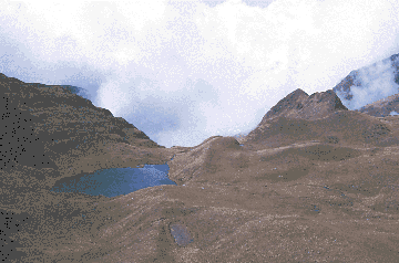 d continues north into the
unexplored plateau of Pantiaqolla. It has branches that head east, away from
the trunk and down toward the westernmost reaches of the Amazon basin, toward,
some say, the legendary ultimate Incan refuge of Paititi. It is to this
undulating highland area that we come, in order to approach Mameria, and
there to seek clues in our own quest to find and document ancient Incan
habitation of the selva. d continues north into the
unexplored plateau of Pantiaqolla. It has branches that head east, away from
the trunk and down toward the westernmost reaches of the Amazon basin, toward,
some say, the legendary ultimate Incan refuge of Paititi. It is to this
undulating highland area that we come, in order to approach Mameria, and
there to seek clues in our own quest to find and document ancient Incan
habitation of the selva.
Fig.1: The bleak, mysterious highlands of the Cordillera de Paucartambo,
which overlook the selva alta below (photo: G. Deyermenjian).
Our own journeys to Mameria had been preceded by those of an eclectic handful
of adventurous souls. It is said that sometime in the 1960s, one Hernán
Flores arrived at a part of what came to be known as Mameria to look for
gold. Over 20 years later, in 1979, a group of opulently supplied French/Peruvian
adventurers, led by Herbert and Nicole Cartagena, landed their helicopter
at a lonely campesino shack in the cordillera, a full day’s walk away
from the colonial-era town of Paucartambo. They were seeking Paititi, and
wished to find a jungle area where there would be Machiguenga Indians and
Incan ruinas, somewhere down to the east. They needed someone to climb aboard
and guide them, they told the inhabitants, one Don Tomás Toledo and
his two sons, Goyo and Gavino. Goyo recognized the knock of opportunity and
jumped aboard, forever changing his own destiny and that of many others.
He pointed the copter’s pilot to the northeast, down to the selva alta,
and where he saw native huts he bade his benefactors to land. They touched
down in Mameria at a Machiguenga chacra, a patch of cultivated land and a
couple of huts making up a typical isolated household settlement. After over
a month, getting along well with their native hosts, being shown various
nearby Incan remains, and making an unsuccessful attempt to scale a mysterious
and legendary tropical peak, Apu Catinti, they returned to Cusco.
Goyo realized over the course of the next year that he would prefer the life
of a free jungle Indian to that of a campesino, attempting to eke out a living
in the cold, harsh highlands. So he walked for over a month, following an
unnamed ridge, guided by his preternatural sense of direction and survival,
and finally reappeared before the Machiguenga. Upon his arrival he apprenticed
himself to the local men, and within a year had two Machiguenga wives (fig.2)
- sisters whose father had been killed by an adjacent tribal group known
as the Kugapacoris - fluency in the language, and all the skills needed to
thrive.
But while Goyo
had been pondering his future and finalizing his ideas to forsake his native
highland for the jungled land that lay below the clouds to the east, others
were carrying out their own venture. General Ludwig Essenwanger of the Peruvian
Air Force, accompanied by Padre Juan Polentini, a peripatetic Salesian priest
obsessed with finding Paititi, came to Mameria. Like the Cartagenas, whose
findings in Mameria had probably provided them with the idea of making their
own foray, the general and the priest arrived by helicopter, but were also
accompanied by military troops and equipment. They came to a particular broad
hilltop that was 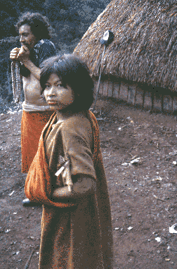 covered with ruinas; the general ordered the airlifted
land-moving machines and power saws to be used in combing the site for treasure.
He then ordered countless artifacts to be flown to their base at the military
outpost of Salvación, in the lower jungles of Manu to the east. From
Salvación, military trucks covered in thick tarps carried the loot
along the winding dirt road that goes all the way to Cusco. Their mysterious
night-time passing through Paucartambo is something the Paucartambinos still
remember in stories they relate to an interested outsider in hushed tones,
as if the very memory of the trucks, like the trucks themselves over twenty
years ago, is something best not investigated too openly. covered with ruinas; the general ordered the airlifted
land-moving machines and power saws to be used in combing the site for treasure.
He then ordered countless artifacts to be flown to their base at the military
outpost of Salvación, in the lower jungles of Manu to the east. From
Salvación, military trucks covered in thick tarps carried the loot
along the winding dirt road that goes all the way to Cusco. Their mysterious
night-time passing through Paucartambo is something the Paucartambinos still
remember in stories they relate to an interested outsider in hushed tones,
as if the very memory of the trucks, like the trucks themselves over twenty
years ago, is something best not investigated too openly.
Fig.2: Goyo and youngest wife, "Carmen" in 1984 (photo: G.
Deyermenjian).]
In 1982, with Goyo having not emerged from his forest hideout for two years,
his younger brother Gavino, along with another rugged campesino named Guillermo
Mamani, descended from the highlands to look. Gavino had no idea if Goyo
was alive or had been killed, nor what his own reception would be, but he
had made a conscious decision that Si me matan, me matan (If they kill me,
they kill me); but determine his brother’s fate, he must. They climbed
the tallest trees atop the highest hills, to orient themselves with their
destination through the occasionally spied faraway wisp of smoke that could
only come from the chacras of the Machiguenga, as had the scattered army
divisions of Topa Inca Yupanqui in efforts to rendezvous with their comrades
in the jungles of Cosńipata, around the Río Pilcopata, 500
years before. Gavino and Guillermo then descended further, to the boulder-strewn
and slippery beds and narrow beaches of the rivers of the high-altitude jungles,
to be the first ever to use that route to Mameria, where they found Goyo
not only very much alive, but having become something of a regional power
in the area, an hombre poderoso.
The next year, the relative quiet of this jungle fastness was broken by the
arrival of Carlos Cartagena, the younger brother of Herbert of 1979’s
aerial expedition. A party consisting of himself and one Manuel Guevara,
César Vílchez, and Vílchez’s nephew, César
Medina, trekked confusedly for a month before finding its way to Mameria,
where the younger Cartagena’s demands of “Take me to Paititi!”
and drunken threats of “I will kill Goyo!” were met by a sullen
and total shunning, such that the Machis denied him even their food. Thus
it fell upon the more diplomatic Vílchez to keep Cartagena from starving
by surreptitiously supplying him with a portion of his own provisions. The
group finally made it back to Cusco, tattered, emaciated, and exhausted.
And so it was in 1984 that we began entering this little-known world far
to the north-northeast of the ancient Incan capital of Cusco. Our goal was
to seek answers to the question of Paititi: was there a major site yet to
be found in the unknown lands beyond the Andes, and what exactly of the ancient
Incan penetration of this jungled expanse? The vast majority of the peoples
of the Incan Empire had been highlanders, as are their Quechua-speaking
Amerindian and rural mestizo descendants of today. Yet much of Incan and
Andean iconography shows a direct and powerful influence of the lowlands
on the highlanders’ psyche: the harpy eagle; jaguar; amaru, or great
and wise serpent; and the crocodilian caiman, all animals/symbols from the
selva, are dominant. And it was gold from beyond the mountains that made
for the most sacred of Incan decoration, and the feathers of tropical birds
that were required by the sumptuous Incan court. We, as well, would go east,
to the land of the Antis, the native peoples of the lowlands, to see for
ourselves what of the Incas was there.
Some years our route would take us by vehicle along the dirt roads just beyond
Cusco, past the town of Calca, and then from Amparaes in the valley of the
Río Yanatile we would take mules and pack horses up into the Cordillera
de Lares. Crossing this range by way of antique trails, we then would descend
to the Río Paucartambo-Mapacho, cross its rickety bridge far below
the village of Parobamba, and then climb into the mists of the Cordillera
de Paucartambo. Other years we went from Cusco through Paucartambo to the
end of the rough road just beyond Challabamba that followed the course of
the river, where Goyo’s father, Don Tomás, would meet us with
the animals that would carry our supplies up into the Paucartambo range.
Once in the cordillera, we would head ever north, traversing its ridge, trudging
interminably through a succession of uncomfortable phenomena, which followed
the same basic pattern day after day: ice on the tents in the morning; slogs
up and over various tundra-like rises in the high puna at an average of over
12,000 feet altitude; penetrating neblina, an enveloping mist, and llovizna,
a chilling drizzle; a searing mid-afternoon sun that makes one long for a
return of the mist and drizzle that one had just been cursing a half hour
before; and the paralyzing cold that descends over everything as soon as
darkness falls at 6:10 pm every evening. Our route
along this high range, these alturas, took us along the trunk of that unmapped
Qhapaqńan, the Incan road of stone that began far to the south, near
Q’eros, past Paucartambo, and on north through its Cordillera, final
destination unknown. Its flat paving stones would appear, then dissipate
into nothingness a little further along, then reappear. We passed Inka Chaca,
or Incan Bridge (fig.4), where the stones were especially visible, appearing
like a connector between two bare expanses of road. We passed various Incan
tambos, or resthouses of rough stone that would have accommodated chaski,
official runners who carried messages. We passed the peak known as
“Huascar,” named after the last Incan emperor in Cusco before the
arrival of the Spaniards in Peru. At 12,500 feet we came to the petroglyph
site known as “Demarcación,” a rock face covered with bas-relief
representations of walking human figures, llamas, faces, and various geometric
designs, appearing to point one toward the east . And finally, at the end
of a highland journey lasting almost a week, we would begin a slight descent
to a perpetually boggy area of high grass that stood at the edge of the mountain
range, facing east - it being the highest point (along with the aforementioned
isolated peak, Apu Catinti) between here and the Atlantic thousands of miles
away, and offering a portal down through the cloud forest to the true jungles
below. . And finally, at the end
of a highland journey lasting almost a week, we would begin a slight descent
to a perpetually boggy area of high grass that stood at the edge of the mountain
range, facing east - it being the highest point (along with the aforementioned
isolated peak, Apu Catinti) between here and the Atlantic thousands of miles
away, and offering a portal down through the cloud forest to the true jungles
below. Fig.3: "Inka Chaca," meaning "Incan Bridge", a portion of the camino
de piedra, or stone road, that traverses the Cordillera de
Paucartambo. A branch of this trunk road heads off toward San Martín
and the jungles of Mameria (photo: G. Deyermenjian).
This cold, wet, flea-infested place, at 10,100 feet, is known as San
Martín, and here we would wait for a break in the weather - the
alternating neblina, rain, and hail that would assail us sometimes for days
on end - for our chance to leave our prison of chilled discomfort. Then,
with a few steps over what seemed to be the eastern edge of the world, we
found ourselves descending dizzily through the bosque de nubes, the cloud
forest. For over three hours we lowered ourselves through a suffocating
monochrome of green and brown, the tangled mass of trees, rotting stumps,
vines, moss, and brambles below, around, and above us, all twisted and serpentine
in its clinging to this near-vertical wall of the Andes. This dense vegetation
that made our downward traverse so difficult was also what made this route
possible, in providing the handholds and footholds that eventually brought
us to a tiny valley below.
The stream that flowed through this valley, and that became the torrent known
as the Río San Martín, was our only trail, and so we followed
it ever downward, crossing and recrossing its path, climbing up into the
monte, the steep jungled hillside, to go over and around various pongos,
where the sheer rock walls of the canyon dropped directly to the water, before
we could drop once again down to our watery highway. Sometimes we found ourselves
scrambling over a mass of gargantuan boulders that had come loose from the
adjacent hillside and tumbled into the river, dragging with it huge tree
trunks, under which we could hear, but barely see, the waters flow. We held
our breath as we jumped from one to another, casting furtive glances at the
collection of loose stones left still lining the hillside immediately above
us. At a point two days downriver, we left the San Martín to climb
for a number of hours up and over a rise to our north-northeast -the top
of which provided us with a mirador, a viewing point from which to locate
the hill upon which would lie Goyo’s chacra, as well as the much higher
peak of seven points beyond that, the base of which was said to be inhabited
by the Kugapacoris - then slip and slide through moss and mud down to another
river, the Sarhuato. We resumed our journey by walking again downriver, finding
the going even more acidentado (slippery and fraught with falls) than before,
what with more pongos, and with the stones beneath the Sarhuato being much
more slimy, since this river carried more vegetative matter than the higher
altitude San Martín.
On our initial
journeys to Mameria, we would descend all the way to the Sarhuato’s
meeting with the Mameria, then follow this major stream upriver to a point
at which a gigantic log had been felled to span the river, affording a ready-made
bridge across the torrent. Once across, we would climb up through the jumble
of burnt logs and thorny bushes that make up plots of land utilized in swidden
(slash and burn) agriculture, to emerge, covered with red biting ants, at
two Machiguenga thatch-roofed huts at Chakupangu, Goyo’s principal chacra
(fig.4). Later years would find us crossing from the right to the left bank
of the 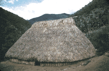 Sarhuato locking arms together against the current before its encuentro,
meeting point, with its mother stream, to climb from there directly up and
over the hill also called Chakupangu, to thence descend to Goyo and his
Machiguenga family. Sarhuato locking arms together against the current before its encuentro,
meeting point, with its mother stream, to climb from there directly up and
over the hill also called Chakupangu, to thence descend to Goyo and his
Machiguenga family.
Fig.4: Machiguenga dwelling built by Goyo at Chakupangu (photo: G.
Deyermenjian). The Machiguenga people, who, along with the Campa and Piro had been the jungle
dwelling Antis of Inca lore and legend and whence comes the term Andes, had
always carried with them certain vestiges of Incan influence, as we came
to see here amongst Goyo’s Machiguenga wives and their relatives and
neighbors on widely scattered hillsides: their cushmas, togas of wild cotton;
the tsagi, cotton shoulder bag; nose ornaments; the use of the fire-fan and
of the coca leaf; as well as various words that have become a part of the
Machiguenga language since being lent them by the Incan’s Quechua tongue,
such as michi for cat, birakoca for lighter-skinned outsider, kori or
kúriki for gold or ornaments, among others. We came to learn, as well,
that these people had arrived at this area of the selva alta relatively recently,
having in the 1960s escaped from the valley of the Río Yavero, where
they were kept by highland and mestizo settlers in a state of virtual slavery,
and made an epic journey that carried them finally here. In Mameria they
found the isolation from the national culture that they were seeking, but
at a price: its 100 square miles, at an altitude that ranges from 3,200 to
5,200 feet, can be uncomfortably cool at night, with survival against the
harsh elements requiring a constant struggle, and with an unexpected proximity
to the Kugapacoris that subjected them to raids well into the 1980s.
These Machiguenga, had, as well, situated themselves in an area that had
at one-shaped metal ornaments; a short metal rod, the top of which was in
the form of double spirals extending out and away to the side of each other;
as well as ceramic plates, which had been deliberately buried, one on top
of the other. Goyo would go off into the surrounding forest and strip large
coca leaves from wild coca trees, which must have been the feral descendants
of the bushes cultivated here in antiquity by the Incas. And we came to realize
that Goyo’s Machiguenga-style palm thatch roofed house had incorporated
as part of one wall an Incan wall of stone - most likely a retaining wall
for an agricultural terrace of old - reminiscent of much of post-conquest
Cusco, where the bases of what had at one time been various important Incan
edifices of stone have been since the 1500s topped by stucco Spanish
constructions.
Searching for Inca ruins: From this Chakupangu, and in later years from various
of Goyo’s newer chacras higher up away from the river, we made a number
of expeditions to search for and document the existence of Incan ruinas.
Our initial trip took us up to the top of this very hill, where the thick
tangled maleza, or undergrowth, of the selva alta gave way to the higher
and larger trees of a slightly cooler mini-climate, reminiscent of that at
Manco Inca’s jungle redoubt at Espíritu Pampa (fig.5) in the
valley of the Concebidayoc-Cosireni well over a hundred miles to the west.
We began to espy large and small pottery fragments. Then came into view various
Incan walls and structures, all of a rough rustic construction, which employed
uncut stones piled skillfully atop each other without mortar of any kind.
There were many circular tombs, subterranean chullpas, which had been sacked,
the stone fillings strewn all about. Large trees had been knocked over, the area around
them having been dug up. Piles of hundreds of stones remained from walls
that had been pulled apart. It became apparent to us that this was the site
at which Essenwanger, Polentini, and the general’s troops and equipment
had arrived nearly four years before. We photographed what had been left
of the extensive site that we dubbed “Chakupangu Arriba,” and
diagrammed the remains of a three-sided structure, with the longest wall
being 28 feet long and one yard high, oriented directly north-south, and
with two arms perpendicular to each end, extending out about 12 feet. There
were some short walls that appeared to be circular, something that could
indicate either a pre-Incan influence, or that they served as part of a rough
storehouse. The general and his men had left many of the ceramic items, such
as vases with spouts in t he form of human faces, probably having been much
more interested in items of financial worth. Paulino Mamani - who had told
me back in Amparaes that he was five years older than he really was, so that
I would be more disposed to agree with this teenager’s request to sign
on with us, and who has since been my most frequent and valuable expedition
partner - cut down a large palm tree, and we feasted on scrumptious and tender
heart of palm before heading back to Chakupangu. he form of human faces, probably having been much
more interested in items of financial worth. Paulino Mamani - who had told
me back in Amparaes that he was five years older than he really was, so that
I would be more disposed to agree with this teenager’s request to sign
on with us, and who has since been my most frequent and valuable expedition
partner - cut down a large palm tree, and we feasted on scrumptious and tender
heart of palm before heading back to Chakupangu.
Fig.5: Regional map showing sites, cities, and towns mentioned in
the text, with Mameria in red and the peaks of Apu Catinti (1) and San
Martín (2) each indicated with a "+".
Soon thereafter, we left Goyo’s settlement to follow the Mameria downstream,
past its encuentro with the Sarhuato. Much of the time we were traversing
thin ledges along the rock wall above the river. Goyo led us across the Mameria
at a point where another stream, which he called the Gobitea, entered on
the right, flowing from the southeast. We climbed above the always steep
monte that borders the river, after which the land leveled out into a more
gentle, steady rise, and eventually we realized that the bumps in the trail
over which I was tripping were in fact andenes, the remains of rough Incan
terraces. Continuing on, we came to the area to which the Machiguenga and
Goyo had brought Herbert and Nicole Cartagena, and which they in turn had
designated in their book as the Cité de Mameria. Here was an extensive
site, replete with the remains of masma-type Incan construction: structures
open on one side, with a central wall nine feet high, complete with three
slightly trapezoidal window-like niches, which very possibly would have had
a roof of thatch extending from the central wall down to the lower side walls,
perhaps with a wooden supporting beam.
And here, just under the layer of moss that covered nearly everything, were
hundreds of Incan artifacts in the form of more tupus and bell-shaped ornaments
of tumbaga, as well as hollow round metal balls, each with a protuberance
at the top through which was a small hole for stringing, and with a clapper
of stone inside that made a pleasant noise when shaken. There was one small
metal piece that delicately portrayed a long-eared, hook-nosed Incan noble
with hands clasped on his chest, also with a hole for stringing through the
top of his pointy head; and another, of a seated noble
 garbed in
a radiant headdress and cape (fig.6). And there were ceramics, such as Incan
vases with protuberances of animal head motifs used for handles. Some artifacts
defied identification, such as long thin metal strips punched by a series
of small holes all in a row. It appeared that the salient archaeological
point was that all these remnants of an ancient presence here were of an
Imperial Incan style, yet of a rough, rustic construction. In this broken
territory there were of course no remains of kallanka, great halls; no usnu,
thrones or platforms; and no gabled edifices or double-jamb doorways that
would have indicated anything more significant than living or working quarters. garbed in
a radiant headdress and cape (fig.6). And there were ceramics, such as Incan
vases with protuberances of animal head motifs used for handles. Some artifacts
defied identification, such as long thin metal strips punched by a series
of small holes all in a row. It appeared that the salient archaeological
point was that all these remnants of an ancient presence here were of an
Imperial Incan style, yet of a rough, rustic construction. In this broken
territory there were of course no remains of kallanka, great halls; no usnu,
thrones or platforms; and no gabled edifices or double-jamb doorways that
would have indicated anything more significant than living or working quarters.
Fig.6: Incan figure with radiant headdress and cape.
In subsequent years, again in Mameria, we returned to that Cité de
Mameria area, finding there a slightly underground horno, a kiln, inside
of which was still a thick layer of ash, which must have been the origin
of all the distinctly Incan, yet roughly made, ceramics (and which gave to
the site the name by which it has since come to be known, El Horno). Back
at Goyo’s chakupangu, we were presented with more unidentifiable artifacts
that Goyo had unearthed in the expansion of his upper chacra, including a
large stone sculpture, called by him Sirena, mermaid, and perhaps representing
a llama. And we traveled farther down the Mameria, to ascend the area around
its affluent, the Mapitonea. We found each hilltop here, within view of the
northernmost peak of the massif of Apu Catinti, to be capped with the stone
remains of Incan platforms, most likely having been used for adoration of
the sun. Then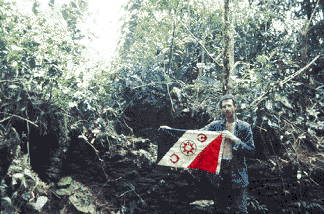 before pushing our way through a nearly treeless area, where
that same sun beat down upon us, and the lack of a canopy allowed the growth
of a hellish and endless mat of six-foot-high, thick, dry underbrush that
allows no one to pass without a struggle, regardless of the skill of the
Paulino or Gabino who may be cutting with the lead machete, we uncovered
various walls. before pushing our way through a nearly treeless area, where
that same sun beat down upon us, and the lack of a canopy allowed the growth
of a hellish and endless mat of six-foot-high, thick, dry underbrush that
allows no one to pass without a struggle, regardless of the skill of the
Paulino or Gabino who may be cutting with the lead machete, we uncovered
various walls. Fig.7: The author with The Explorers Club flag in front of the recessed
structure at "Arete Perdido" (photo: P. Mamani). Here we also found what was for me a quite unexpected discomfort,
the extreme thirst that dogs one in the selva alta, where streams and brooks
away from the main rivers are scarce or nonexistent. But our privations were
countered by our coming to a site that Goyo had described as a
“mini-Saqsaywaman” - in reference to the uniquely famous zig-zag-shaped
ceremonial center/ fortress above Cusco - where we, in fact, found a stone
edifice with a second, recessed level, enclosed on all four sides by long
walls of over thirty feet in length, with double walls on one side, passageways
and raised areas inside, and an uncharacteristic asymmetrical shape (fig.7).
It stands as the largest Incan ruin yet found in the jungles to the northeast
of the Cordillera de Paucartambo, and gives the impression that its uniqueness
could indicate that it had some important administrative function for this
entire area in Incan times. Our thirst was so intense, and the flying insects
were so extremely oppressive - in the mid-day heat here in the area since
dubbed by Goyo as Arete Perdido (Lost Earring), for the ornament that I had
lost nearby, to the tugs of the maddening vegetation - that after an hour
and a half of clearing, photographing, measuring, and drawing the site, we
needed to leave in a hurry.
Other
journeys through Mameria brought us far to the southeast of Chakupangu, after
crossing the Sarhuato, and then the Río Niatene, to where we found
ourselves standing in rivulets that flowed toward the upper reaches of the
Mapitonea, at the southern base of Apu Catinti. This mountain, covered almost
to its top in a thick mantle of vegetation, had been prominent in legends
as holding the key to the Incan Paititi, yet our hard-fought ascension of
this peak suggested that no one, not even the Incas, had ever before reached
its 10,000 foot summit. On our return towards Chakupangu, in the area of
the Niatene, Goyo, Paulino, Gavino, and our Machiguenga companion,
“Angel,” uncovered from a layer of moss an extremely well-made,
tightly fitted stone wall. In journeying northwest of Chakupangu, desirous
of coming to the Mameria far upriver to ascend to its furthest headwaters,
we found that the area beyond the Río Choritia was also honeycombed
with rough, widely dispersed Incan walls. And in other trips downriver, we
went then north of the Río Mameria, to areas known as
“Ichiminea” where the river of that name enters the Mameria’s
tributary, the Kiteni, and then further downstream to “Adumbaria,”
to visit the extensive chacras of the Machiguenga man known as
“Raimundo”; here we found, on that side of the large river as well,
evidence of an antique Incan presence represented by various short stone
walls.
It has been posited by some that this Mameria constitutes Paititi, or a satellite
of some yet unfound larger metropolis. Given that these remote areas of
jungle-covered hills and mountains are so vast and so well-hidden and protected
from the outside world by Pacha Mama, the Andean Earth Mother, the selva
alta could indeed hide some things forever. And the existence of the unmapped
camino de piedra that traverses the highlands with branches appearing to
head toward Mameria, could also indicate that these ruins constitute some
part of an interconnected Incan state within the Antisuyu, the still mysterious
eastern quarter of the Incan empire. What is more certain is that Mameria
was one of the regions that provided the essential and sacred coca to the
Incan nobility, whose prerogative it was to chew. A carbon-14 analysis of
a charcoal sample we found in Mameria, from a hearth that appeared to be
contemporaneous with the ruins atop the hill of Chakupangu, gave a date of
AD 1345, with a range that extends from as early as 1240 to as late as 1500
(Lab # GX-15555). This works against any hope of Mameria constituting a
post-Conquest refuge, such as was Vilcabamba at Espíritu Pampa. The
role of grave tropical diseases, especially Leishmaniasis, to which the Andeans,
like the Spaniards after them, would have had no natural immunity, must also
be figured in, regarding the limitations to a possible long-term presence
in the lowlands.
The full story, then, of Mameria, an area of relatively extensive Incan
habitation east of the Andes, and its connection to the Incan polity in the
highlands, as well as its relations with the Antis at the edge of the known
Incan world, remains to be investigated and written about more completely.
Bibliography/further reading: .
Amighetti, B., C. Burati, F. Kauffmann Doig, C. Neuenschwander Landa, S.
Rosi-Osmida, and V. Sartor. 1995. Antisuyu - Ultimo Sogno Inca. Venice, Erizzo
Editrice, Centro Studi Ricerche Ligabue di Venezia.
Angles Vargas, V. 1992. El Paititi no existe. Cusco, Imprenta Amauta S.R.
Ltda.
Cartagena, N. and H. Cartagena. 1981. Paititi: Dernier Refuge des Incas.
Paris, Éditions Robert Laffont.
Cartagena, N. and H. Cartagena. 1998. “A la recherche de Paititi, cité
perdue du Pérou.” GEO.
Ceballos Bendezú, I. 1982. “Fauna de Callanga y Nueva Ubicación
Geográfica de la Localidad del Río Kallanqa en el Cusco.”
Cantua, Edición Extraordinaria 9/10: 31-49. Cusco, UNSAAC.
Deyermenjian, G. 1988. Land Rights, Cultural Survival and Innovation Among
Indigenous Peoples of the Western Amazon Basin: the Case of the Machiguenga.
Master’s Thesis, Clark University.
Deyermenjian, G. 1990. “The Toporake/Paititi Expedition: On the Trail
of the Ultimate Refuge of the Incas.” The Explorers Journal 68(2): 74-83.
Deyermenjian, G. 1999. “Glimmers of Paititi: Searching for a Lost Incan
Refuge.” Mercator’s World 4(1): 42-49.
Gade, D. 1999. Nature and Culture in the Andes. University of Wisconsin Press.
Gasparini, G. and L. Margolies. 1980. Inca Architecture. P.J. Lyon (trans.).
Bloomington, Indiana University Press.
Gutierrez Pareja, S. 1984. “Caminos al Antisuyu.” Revista del Museo
e Instituto de Arqueología 23: 63-92. Cusco, Universidad Nacional
de San Antonio Abad.
Johnson, O. 1978. Interpersonal Relations and Domestic Authority among the
Machiguenga of the Peruvian Amazon. PhD Dissertation, Columbia University.
Kauffmann Doig, F. 1983. Manual de Arqueología Peruana. Lima, Ediciones
PEISA.
Lyon, P. 1981. “An Imaginary Frontier; Prehistoric Highland-Lowland
Interchange in the Southern Peruvian Andes.” In F. Kense and P. Duke
(eds.), Networks of the Past: Regional Interaction in Archaeology, Proceedings
of the XII Annual Conference of the University of Calgary, University of
Calgary Archaeological Association, pp. 1-18.
MacQuarrie, K. 1992. Peru’s Amazonian Eden: Manu National Park and Biosphere
Reserve. Barcelona, Francis O. Patthey e Hijos.
Mirecki, M. 1985. “A New Search for Paititi.” The Lima Times 510:
6-7.
Neuenschwander Landa, C. 1983. Paititi, En la Bruma de la Historia. Arequipa,
Peru (self-published).
Nunez del Prado, O. 1970. El Hombre y la Familia: Su Matrimonio y
Organización Político Social en Q’ero. Cusco.
Polentini Wester, J. 1999. El Paí Titi. Lima, Asociación
Librería Editorial Salesiana.
Ramos Carpio, C. 1996. Paucartambo: Testimonios de su Patrimonio Natural
y Cultural. Cusco, Impresiones Aguilar EIR Ltda.
This article appears in Vol.3 No.4 of Athena
Review.
.
|
|