|
Gregory Deyermenjian Director, New England Chapter of The Explorers
Club .
The South American nation of Peru is blessed with untold thousands of ancient
rock-art sites. Many have been documented in the exhaustive four volume Petroglífos del Perú by Cuban researcher Antonio Nunez Jimenez
(1986). Yet, it is along the eastern ridge of the Andes, and down into the
dense vegetation of the selva - the rainforest - where some of the most
mysterious, beautiful, and potentially significant sites exist.
Petroglyphs are engravings made on a rock surface. By pecking with a hammerstone,
or cutting with a sharp stone knife, native South American peoples who were
otherwise without written symbols utilized geometric forms in graphic expression.
South American petroglyphs are divided geographically and stylistically into
four separate groups: Patagonian; Ando-Peruvian; Colombian-Venezuelan; and
Brazilian (Boman 1908; Rouse 1949). Patagonian petroglyphs consist of simplistic
figures such as footprints of birds, animals, human beings, human hands, and
concentric circles and squares. Fig.1: Map of route from Cusco to Pusharo (G.Deyermenjian). Those of the Colombian-Venezuelan group include
human or animal figures, always without details of clothing or ornament,
with those from the eastern slopes of the Colombian more resembling
Amazonian types, showing human faces and possible supernatural beings emphasized
through simple, repeated curvilinear or swirling. Brazilia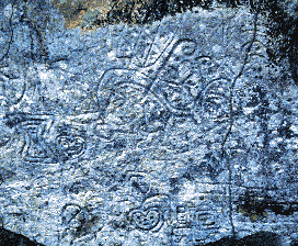 n petroglyphs feature
schematic representations of fish, animals, and human beings, as well as
common designs of faces, circles, and the spiral (fig.2). Ando-Peruvian
petroglyphs, by contrast, employ the most complicated designs of all, with
frequent representations of birds, animals (including felines and llamas),
and human beings. The gigantic Nazca figures in southern Peru represent the
Ando-Peruvian style. n petroglyphs feature
schematic representations of fish, animals, and human beings, as well as
common designs of faces, circles, and the spiral (fig.2). Ando-Peruvian
petroglyphs, by contrast, employ the most complicated designs of all, with
frequent representations of birds, animals (including felines and llamas),
and human beings. The gigantic Nazca figures in southern Peru represent the
Ando-Peruvian style.
Fig.2: A section of the Petroglyphs found at Pusharo (photo:
G. Deyermenjian).
I first encountered petroglyphs in 1984 while my party of highland campesinos
and Peruvian adventurers was traversing the Cordillera de Paucartambo (fig.1), the
easternmost range of the high Andes to the northeast of Cusco. We were at
an altitude of 13,500 feet when we found ourselves astride a rockhang covered with bas- relief
images of llamas and walking humans (fig.3). All the human figures on the
rock were heading in one direction, northeast, toward the tropical forests
This site is named Demarcación, whose meaning would doubtless have
been understood by Incan peoples of old passing this way.
We found the Andean foothills to be honeycombed with ancient Incan
ruins, as well as pottery. And in subsequent years we retur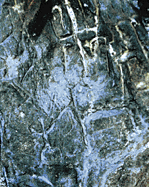 ned, each time
penetrating further beyond our most recent foray. In 1989, at the high, windswept
Meseta, or tableland, of Toporake, just northwest of the jungles of Mameria,
a number of Incan roads of stone converged, with one barely perceptible rail
further north beckoning us toward the unknown plateau, the Meseta de Pantiacolla. Pantay means "to get or become lost," while Qoya means "Inca's wife"
or "Queen;" also, that in at least one specific legend the Pantiacolla is
the final resting place for the culture hero, Inkarrí, founder of
Cusco. ned, each time
penetrating further beyond our most recent foray. In 1989, at the high, windswept
Meseta, or tableland, of Toporake, just northwest of the jungles of Mameria,
a number of Incan roads of stone converged, with one barely perceptible rail
further north beckoning us toward the unknown plateau, the Meseta de Pantiacolla. Pantay means "to get or become lost," while Qoya means "Inca's wife"
or "Queen;" also, that in at least one specific legend the Pantiacolla is
the final resting place for the culture hero, Inkarrí, founder of
Cusco.
Fig.3: Human and llama figures in Pusharo petroglyphs (photo: G. Deyermenjian).
In 1991, our Pantiacolla/ Paititi Expedition was ready, but Peru's political
situation that year had worsened, and the Province of Calca was in a temporary
state of emergency because of the activity of political subversives and bandits.
We decided to avoid it and travel much further northeast from Cusco to the
selva baja of the Province of Manu (fig.3).Here, we would investigate the
"Petroglyphs of Pusharo." We frequently had to push and pull and dig to extricate
the van from the mud that usually was negotiated only by the powerful Volvo
freight trucks that made the days-long run between Cusco and the frontier
river towns down in the lowlands.The van had an easier time of it once we
emerged onto the plains at 3,300 feet.
In the jungle, all words become softened: "Pusharo" would be the lowlander's
parlance for "Pucharo," which some claimed was a corruption of the Quechua Pukara, meaning "fortress," or of Puchu Karu, meaning "far away remains."
It appears that a rubber tapper on an Indian raid in 1909 may have been the
first non-native to encounter the Petroglyphs, describing them as "gothic
letters." But it was not until 1921 that they were examined and drawn, by
a Dominican missionary, who concluded their visit by declaring that the arcane
figures re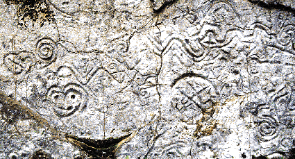 presented scenes from the Old and New Testaments. Not until 1953
or '54 was the site
again
reached by an outsider, a Sr. Jorge Althaus of Cusco. In 1969 Dr.
Carlos Neuenschwander, thwarted by thick cloud-cover in his desire
to make an aerial
reconnaisance of the Meseta de Pantiacolla, had the helicopter at his
disposal
bring him instead to Pusharo. presented scenes from the Old and New Testaments. Not until 1953
or '54 was the site
again
reached by an outsider, a Sr. Jorge Althaus of Cusco. In 1969 Dr.
Carlos Neuenschwander, thwarted by thick cloud-cover in his desire
to make an aerial
reconnaisance of the Meseta de Pantiacolla, had the helicopter at his
disposal
bring him instead to Pusharo.
Fig.4: some examples of the Petroglyphs of Pusharo
(photo: G. Deyermenjian).
We put in at the Native Community of Palatoa Tepa, where Machiguenga had
gathered to live in what was for them an atypically dense concentration of
perhaps a dozen families. We needed to acquire a Machiguenga guide. Also,
we wanted a native person to provide introduction, and assurance of our friendly
intentions, to the more nomadic Machiguenga we would certainly encounter
further upriver. But, strangely, none of the Machis wanted to go with us.
I found out that their reticence stemmed from some other party of extranjeros
- outsiders or foreigners - having used them as guides and then not paid
a single centavo. I insisted to the village headman that we were a different
breed than our ill-mannered predecessors, and backed it up with an offer
to pay in advance.
After having trudged upriver to 2,600 feet, we heard a dog wildly barking,
and then approached a small band of Machiguenga, living by the river in what
looked like a hastily constructed lodge of bent sticks covered with leaves
.Soon the valley widened. This was it. As we moved from left to right along
the length of the Pusharo monolith, the figures seemed to increase in baroque
complexity. They covered the rock for three quarters of its length, and reached
up to eight feet. "A picture's worth a thousand words" was never more true
(fig.4). Having filmed and photographed all that I could of Pusharo, it was
time to head back downriver. The rainy season arrived with a vengeance, that
night we stayed with some hospitable Machiguenga. The next morning, we bid
these most gracious people goodbye, Machiguenga themselves never say goodbye
to anyone. Down the Palatoa to soon meet our canoe at the Native Community,
then our van at Atalaya, and eventually our lodgings in Cusco (fig.1).
What now are
we to make of the Petroglyphs of Pusharo? Although within Peru, this site
appears to fall stylistically toward the Brazilian group: it contains all
the geometric forms associated with lowland designs, and none of the typically
Andean naturalistic forms such as birds, llamas, and human beings. All the
glyphs are abstract. Some of the designs are found in many areas of the northwest
Amazon: as petroglyphs in Brazil's valley of the Río Negro, Colombia's
Calima valley, and several other places. Those who have commented upon Pusharo
usually suggest any one of four possible interpretations. Some see it as
a t errestrial map, with its various serpentine lines indicating rivers,
mountains, and various other natural features. They see significance in the
fact that it lies in a transitional zone between the lower selva and the
highlands, thus being a crossroads for migrating populations that may have
sculpted a map in the rock to record their wanderings, or the area from whence
they came. Some see it as a gigantic map of the heavens. Some see in these
Petroglyphs evidence of pre-Columbian trans-Atlantic contact. errestrial map, with its various serpentine lines indicating rivers,
mountains, and various other natural features. They see significance in the
fact that it lies in a transitional zone between the lower selva and the
highlands, thus being a crossroads for migrating populations that may have
sculpted a map in the rock to record their wanderings, or the area from whence
they came. Some see it as a gigantic map of the heavens. Some see in these
Petroglyphs evidence of pre-Columbian trans-Atlantic contact.
Fig.5: Photo of the author.
The Petroglyphs of Pusharo strike most viewers as weird, confusing, and
fascinating. We may never know what these glyphs mean. We may, however, be
able to understand something of the psychological and cultural motivations
behind their creation. Whenever it was that these petroglyphs were carved,
the northwest Amazon would have been home to countless hundreds of Amerindian
tribal groups. Although most of these groups lived far away from each other,
they must have nonetheless shared many life experiences in their relatively
similar physical environment. They also undoubtedly partook of the same
hallucinogenic plants, especially Ayahuasca, but also Brugmansia.
They must have seen similar visions, and expressed them graphically on their
houses, on rocks by rivers, with an especially lush flowering of expression
emerging at Pusharo.
[Related discoveries by Gregory Deyermenjian are featured
in the article,
The Search
for Paititi.]
References: Boman 1908 Deyermenjian, Gregory 1999. "The Search For Patiti." Athena Review, vol. 2, no.2. Deyermenjian, Gregory 1999. "Discovery of Inca Ruins at the headwaters of the Rio Timpia." Athena Review vol. 2, no.2. Nunez Jimenez, Antonio 1986. Petroglífos del Perú Rouse, Irving 1949
This is an abridged version of the article appearing in Vol.2, No.3 of Athena
Review.
.
|
|