|
The ancient desert settlements of Khotan and neighboring Silk Road towns
from Chinese East Turkestan to Turkmenistan were once bustling, cosmopolitan
centers that flourished from the exchange of goods, languages, religion and
ideas. The Silk Road, today a busy highway with some recent notoriety for
drug-smuggling, has been crossed by centuries of travellers from Zhang Quian
to Marco Polo. Lands through which the western part of the ancient Silk Road
passed, however, in many ways present a stark contrast to the insular, war-torn
political and economic climate of today’s South-Central Asia.
 China’s
original Silk Road (active from the 2nd century BC - 14th c. AD) led
westward from the T’ang Dynasty capital at Ch’ang An to Tun-huang
at the edge of the Taklamakan Desert, then split at Kashgar into north and
south routes through countries now becoming household names (figs.1, 2).
The north branch crossed Kyrgyzstan and Uzbekistan (with famous market
towns at Tashkent and Samarkand); the southern branch entered Afghanistan
along the Hindu Kush mountains between northern Pakistan and southern Tajikistan,
then passed through the age-old cavern stop and camel center of Bactria.
Converging in Turkmenistan, the Silk Road continued west through Iran to
endpoints at Damascus and Antioch. China’s
original Silk Road (active from the 2nd century BC - 14th c. AD) led
westward from the T’ang Dynasty capital at Ch’ang An to Tun-huang
at the edge of the Taklamakan Desert, then split at Kashgar into north and
south routes through countries now becoming household names (figs.1, 2).
The north branch crossed Kyrgyzstan and Uzbekistan (with famous market
towns at Tashkent and Samarkand); the southern branch entered Afghanistan
along the Hindu Kush mountains between northern Pakistan and southern Tajikistan,
then passed through the age-old cavern stop and camel center of Bactria.
Converging in Turkmenistan, the Silk Road continued west through Iran to
endpoints at Damascus and Antioch.
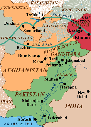
Fig.1: Map of the western Silk Road region
between China and Iran, with modern political boundaries.
In Chinese Turkestan, the ancient province of Khotan lay along this east-west
corridor connecting China with several early, hybrid civilizations including
the Indo-Scythian (-Kushan), and Graeco-Buddhist (Gandharan) cultures in
Afghanistan and Pakistan, plus commercial elements from the Greek, Roman,
and Byzantine Empires further west. Although Khotan’s buried cities
were rediscovered a century ago, today the unique archaeological remains
in this region are tragically caught in a warzone’s crossfire of
destruction. Furthermore, many Buddhist and other religious and cultural
remains considered taboo by Islamic fundamentalists have recently been destroyed.
An ancient cultural melting pot: The region
from Turkestan to Afghanistan has a long term history as a cultural crossroads.
Between 2500-1700 BC, the Punjab in the Indus Valley of Pakistan was home
to the Harappan civilization, one of the world’s first urban cultures,
with writing, roads facilitating long-distance trading networks, and major
cities at Mohenjo-Daro and Harappa. Later, in the 4th to 1st centuries BC,
the region witnessed an influx of Greek, Iranian, Palmyran, Parthian, Tokharian,
and Chinese influences. Bactria (today’s Balkh in northern Afghanistan)
was then the wealthy capital of the independent Bactrian kingdom, combining
Hellenistic and Indian cultures. In nearby northern Pakistan, meanwhile,
the Gandharan kingdom flourished from the 3rd century BC to the 4th century
AD (eventually falling in the 6th c. AD to Hephtalites or White Huns). Centering
at Taxila on the Indus River near today’s Islamabad, the Gandharan culture
incorporated eastern and western (Graeco-Buddhist) art, symbolism, and
architecture. Starting with King Ashoka (273-232 BC), Gandhara served as
a gateway between India, Central and Eastern Asia, and the Mediterranean,
promoting the spread of Buddhism, art, and mercantile culture northeast to
the Tarim Basin and China.
By the 1st century BC, the Gandharan civilization was closely linked to the
trading centers of Khotan. Despite being located in a relatively harsh
environment skirting the Taklamakan Desert, both archaeological and historical
evidence reveal that, for a full millennium, the ancient Khotan settlements
thrived as places of economic, religious, and cultural exchange between east
and west.
Rediscovery of Khotan: Clues to over a
thousand years of major Silk Road settlements remained hidden in Chinese
Turkestan’s desert sands until exposed between 1896 and 1910 by two
of the most intrepid explorers ever known, Sven Hedin and Aurel Stein.
Unexpectedly well preserved finds from the ancient Kingdom of Khotan dating
from the 2nd century BC to after AD 1200 revealed that a forgotten commercial
and cultural crossroads prospered there in the 1st millennium AD. Although
the region is largely Islamic today, ancient merchants carried Buddhism along
with their goods on the Silk Road, allowing it to flourish throughout this
gateway to China.
In the center
of Western Turkestan’s Tarim Basin lies the forbidding, nearly waterless
Taklamakan Desert, first accurately mapped by geographer Sven Hedin in the
late 1890s (figs.2, 5). Over 750 miles wide (EW), the desert is flanked on
the north by the Tien Shan mountains, and on the south by Tibet’s imposing
Kunlun range. Spring-fed rivers that ran through this barren desert, supporting
the Silk Road trade centers in Khotan, were harnessed by sophisticated irrigation
systems and yielded cobbles of jade, the sanctified green stone sought throughout
the ancient Orient. 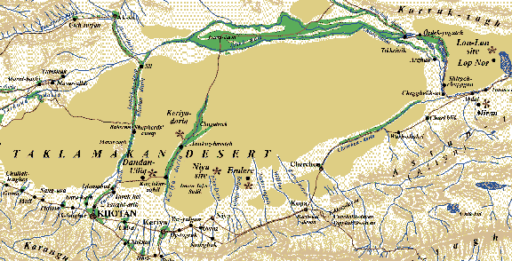
Fig.2: Map of the Tarim Basin, with sites
found by Sven Hedin and Aurel Stein (after Hedin 1898 and Stein 1933).
When Marco Polo passed through Turkestan in 1271 (fig.3) on his way to the
court of Kublai Khan at Khanbalik (Beijing), he reported that Khotan - by
then, long converted to Islam - still remained prosperous:
“Khotan is a province 8 days journey in width, subject to the Great
Khan. The inhabitants all worship Mahomet. It has cities and towns in plenty,
of which the most splendid, and the capital of the kingdom, bears the same
name as the province, Khotan. It is amply stocked with the means of life.
Cotton grows there in plenty. It has vineyards, estates, and orchards in
plenty. The people live by trade and industry; they are not at all
warlike.” [Marco Polo, Travels, chap. 33].
Eventually, by the time of the Ming Dynasty (AD 1386-1644), the rivers that
fed the basin had shifted or dried up. Concurrently, the Ming Emperors’
policy of isolationism drastically reduced the importance of the Silk Road.
As a result, these ancient cities were abandoned to the desert elements,
and buried by sand.
Rediscovery of the buried cities of Khotan around 1900, first by Hedin and
then by archaeologist Aurel Stein (fig.14), revealed an astonishing mixture
of eastern and western cultures, as evidenced by inscriptions from Chinese,
Semitic, and Indo-European languages, and by temple and household objects
combining Asian and Hellenistic art styles. By 330 BC, Alexander the
Great’s conquest of the Iranian Empire had infused Greek language,
adminstration, and sculptural arts into the extant Persian and Indian traditions.
Palmyran and then Parthian tribes reclaimed the region, but Greek influences
persisted through the Bactrian kingdoms of the 2nd-1st centuries BC. The
culture of this region further diversified with subsequent northern Indian
contact. As Stein was to prove, the Kushan people (descendents of the
Yüeh-chih, a group displaced to northern India by Hun ancestors called
Hsiung-nu) moved into the Tarim Basin by the 2nd century BC, bringing with
them writing, Buddhistic beliefs, and commercial ties with the Gandharan
culture on the Indo-Afghan frontier. This melding of traditions produced
striking art forms combining Eastern symbolism with Western realism.
The Silk Road: Knowledge in China of these
cultural movements began with reports by Chinese officer Zhang Quian, called
the “father of the Silk Road.” Emperor Wu Ti (140-87 BC) of the
Han Dynasty had sent Zhang Quian to the Yüeh-chih rulers of northern
India to persuade them to join the Chinese against the Hun progenitors called
Hsiung-nu. After failing to recruit them, being imprisoned by the Hsiung-nu
for 10 of the 13 years of his trip, and returning in 125 BC with only one
of his hundred original men, Zhang Quian nevertheless had gained crucial
information about sophisticated, wealthy societies in the West with a faith
known as Buddhism, and a larger breed of horses that could benefit the Han
militia.
Upon
learning of these Occidental states, the Emperor Wu Ti at once sought to
control the lucrative trade corridor linked to the West that became known
as the Silk Road. Han forces conquered it in 115 BC by beating the Huns back
north of the desert. Starting in 6 BC, the Huns re-seized the contested area
and, during the next 11 years, divided it into 55 territories. The pendulum
swung back for the Chinese in AD 73 under Emperor Ming Ti, when the general
Pan Ch’ao, famed as one of China’s greatest soldier-statesmen for
his use of trickery and skillful diplomacy over brute force, reconquered
the Tarim Basin.
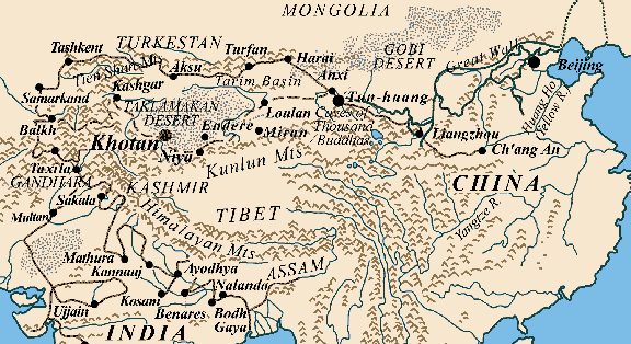 Fig.3: Map of China and Central Asia,
showing Great Wall locations.
Increasing trade amid hostile territories led to the extension of the Great
Wall of China along the Silk Road (fig.2). The Great Wall was first built
at the end of the 3rd century BC, when the Qin (Ch’in) Dynasty (221-206
BC) unified China’s Warring States and connected their regional protective
walls into one solid frontier. Now, to protect new trade networks with India,
Han Emperor Wu Ti extended the Wall westward along the Silk Road. For centuries
it was periodically maintained and lengthened as far as the Tibetan Plateau.
Remains of the Great Wall with 7th-8th century AD guard outposts were found
by Stein as far west as Tun-huang (see below).
Along with facilitating China’s prosperous trade in silk (its manufacture
long a jealously guarded secret) and many other goods ranging from salt and
glass to jade and ivory, the Silk Road provided Buddhism with a ready avenue
for expanding and flourishing in alliance with merchants and urban culture.
Mahâyâna or “Great Vehicle” Buddhism spread from India
to China via the trade route, after the Han Emperor Ming Ti (AD 57-75) was
convinced that the golden figure in his dream was a sign from Buddha. In
AD 68 he sent a minister named Cai Yin to learn about this mysterious god
of the West. Yin returned not only with Buddhist sculptures and scriptures,
but with two Buddhist monks to teach their faith to the Chinese.
Later, by AD 166, Emperor Huan formally introduced the western religion by
hosting Buddhist ceremonies in his palace. At the end of the Han Dynasty,
both regional unrest and disillusionment with the traditional Confucian order
had encouraged people to adopt a new faith (Montell 1935). Buddhism continued
to gain popularity and experienced its greatest inflow into China during
the Northern Wei Dynasty (in the Six Dynasties) in the 4th-5th century AD.
The earliest known Chinese Buddhist image with a precise date, from AD 338,
is a bronze Buddha imitating a Gandharan prototype (Sullivan 1979).
In AD 399-400 Fâ Hsien, a Buddhist monk from China, travelled through
the Khotan province on foot on his way to India to obtain Buddhist texts
for his homeland. On his journey, he made invaluable observations about the
people and places he visited. By AD 514, at least two million people in China
were practicing the religion.
During this
time the Chinese Empire witnessed a boom in the construction of Buddhist
monasteries, stupas (shrines; fig.4), and grottos (cave sanctuaries). Grottos
carved into soft sandstone cliffs were especially abundant on the edge of
the Taklamakan Desert. They often held a wealth of offerings to Buddha from
merchants giving thanks for, or asking for, a safe trek across the unforgiving
desert. Not coincidentally, the Mogao grottos at Tun-huang at the edge of
the desert’s most difficult crossing have yielded some of the richest
caches of Buddhist art and ancient documents, dating from the Northern Wei
Dynasty (AD 386-535). Also known as the Caves of the Thousand 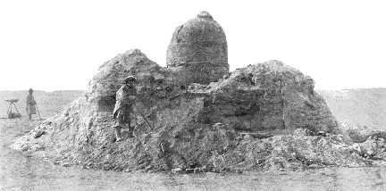 Buddhas, they
were heavily used during the Sui and T’ang Dynasties (AD 581-906). Here,
important new discoveries were made by Stein (fig.8). Buddhas, they
were heavily used during the Sui and T’ang Dynasties (AD 581-906). Here,
important new discoveries were made by Stein (fig.8).
Fig.4: Buddhist stupa discovered by Stein's
expedition at Miran (Stein 1912).
Further evidence for the popularity of Buddhism in China comes from the writings
of 7th century traveller Hsüan-tsang (Xuanzang), who undertook a mission
to collect Buddhist teachings during the height of the Silk Road. Upon his
return, he built the “Great Goose Pagoda” in Ch’ang An, the
capital of the T’ang Dynasty, to house the more than 600 scriptures
he retrieved. Today Hsüan-tsang is seen as an important influence in
the development of Buddhism in China. He also chronicled in great detail
the customs of the people and places of Turkestan as well as Tibet and India.
In his work Hsi Yu Chi, he wrote of Khotan:
“What land there is, is suitable for regular cultivation and produces
abundance of fruits. The manufactures are carpets, haircloth of a fine quality,
and fine-woven silken fabrics. Moreover, it produces white and green jade...They
have a knowledge of politeness and justice...They love to study literature
and the arts...This country is renowned for its music” (Hsüan-tsang,
in Montell 1935:149-150).
Khotan’s
success, which was interdependent upon the strength of the Chinese Empire,
the success of the Silk Road, and the proliferation of Buddhism, suffered
great losses when all three began to decline. In the 10th century AD, the
region witnessed the weakening of the T’ang dynasty in the East and
invasions by Arabs in the West, who brought Islam to the area at the expense
of Buddhist practices and art. Henceforth, while east-west trade continued,
the once-flourishing Buddhist shrines were destroyed or replaced by those
of Islamic culture. The ensuing instability as well as the rise of the Silk
Sea Route caused traffic on the Silk Road to decline.
By the early 1200s, the Mongolian tribes united, elec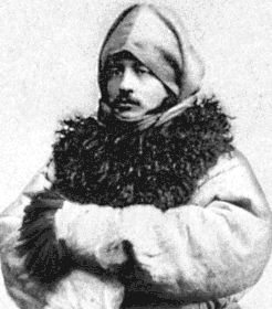 ted a leader, Genghis
Khan, and conquered a huge portion of Eurasia as far west as the Mediterranean.
With the later Sung Dynasty (AD 960-1279) now unable to protect the Silk
Road from Mongolian, Arab, and other invasions, populations and wealth (still
evident at the time of Marco Polo) dwindled in Chinese Turkestan. Shifting
rivers and desert sands soon reclaimed the once-flourishing towns. ted a leader, Genghis
Khan, and conquered a huge portion of Eurasia as far west as the Mediterranean.
With the later Sung Dynasty (AD 960-1279) now unable to protect the Silk
Road from Mongolian, Arab, and other invasions, populations and wealth (still
evident at the time of Marco Polo) dwindled in Chinese Turkestan. Shifting
rivers and desert sands soon reclaimed the once-flourishing towns.
Fig.5: Swedish geographer Sven Hedin,
who first rediscovered the buried cities of Khotan (Hedin 1898).
Rediscovery: Swedish geographer Sven Hedin
(fig.5), who spent much of a long and successful career exploring and mapping
large but little known portions of Turkestan, Tibet, and northwest China,
rediscovered the desert settlements of Khotan in 1896 under highly dramatic
circumstances. After crossing the formidable Kun-lan mountains, whose melting
snows fed streams once flowing through the Taklamakan Desert past ancient
towns, Hedin attempted to cross the waterless desert itself. As described
in his 1898 book, Through Asia, this Taklamakan trek in the summer
of 1896 proved to be nothing short of disastrous. After most of his party,
including all the pack camels, had died of thirst and heat exposure, Hedin
and two companions managed to crawl to safety at an oasis in the southeast
corner of the desert, to be rescued by a passing caravan.
While recovering
at the nearby bazaar town of Khotan, Hedin learned of lost cities along abandoned
riverbeds whose wooden house beams stuck out through desert s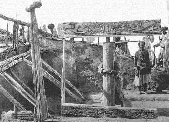 ands, and of
artifacts collected by local people. Within a few months he had visited several
sites at Khotan and Niya, making limited excavations at houses and temples.
Recognizing the significance of the finds which included Buddhist- and
Gandharan-influenced carvings, paintings, and texts, well-preserved in the
dry climate, Hedin reported them in both scientific and general publications. ands, and of
artifacts collected by local people. Within a few months he had visited several
sites at Khotan and Niya, making limited excavations at houses and temples.
Recognizing the significance of the finds which included Buddhist- and
Gandharan-influenced carvings, paintings, and texts, well-preserved in the
dry climate, Hedin reported them in both scientific and general publications.
Fig.6: Ruins of Niya house XXVI excavated
by Stein. Fantastic animal effigies including winged beasts with crocodile
heads are carved on wood panels (Stein 1912).
Hedin’s descriptions of the buried cities soon inspired the Hungarian
archaeologist and linguist M. Aurel Stein to explore Khotan and surrounding
areas. Stein had a mastery of the Oriental languages of northern India, and
a keen interest in deciphering the missing history of Central Asia. In pursuit
of these goals, Stein organized four expeditions into Turkestan and western
China from 1900-1930.
 Leaving Kashmir
on May 29, 1900, Stein and his crew travelled by camel and horseback to reach
Khotan on October 2. Stein ingeniously solved the problems of both crossing
and working in the deadly Taklamakan Desert by travelling in winter and having
camels carry large blocks of ice, an easily transportable source of water.
He proceeded to unearth phenomenal finds in the Tarim Basin at Khotan,
Dandan-Uiliq, Niya, Endere, and other sites as far east as Tun-huang, including
included Buddhist temples and artifacts, house-dwellings, inscriptions, and
ruins of the extended Great Wall. Leaving Kashmir
on May 29, 1900, Stein and his crew travelled by camel and horseback to reach
Khotan on October 2. Stein ingeniously solved the problems of both crossing
and working in the deadly Taklamakan Desert by travelling in winter and having
camels carry large blocks of ice, an easily transportable source of water.
He proceeded to unearth phenomenal finds in the Tarim Basin at Khotan,
Dandan-Uiliq, Niya, Endere, and other sites as far east as Tun-huang, including
included Buddhist temples and artifacts, house-dwellings, inscriptions, and
ruins of the extended Great Wall.
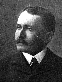
Fig.7: Sir Mark Aurel Stein (1862-1940),
the Hungarian archaeologist who uncovered Buddhist sites from Khotan to Tun-Huang
(Stein 1912).
Buddhist temples and artifacts: Stein
discovered excellently preserved Buddhist temples (called But-khana, or temple
of idols) at Dandan-Uiliq. These had an inner, square sanctuary room or cella,
enclosed by four equidistant outer walls in a square passage used for the
ceremonial processions or pradakshina of Indian custom. In the center of
these rooms were elaborately stuccoed pedestals holding large idols of Buddha
(indicated by remnants of the statues’ feet still in place).
The temple walls of Dandan-Uiliq and elsewhere had paintings and stucco reliefs
of Buddha, Buddhist saints (Bodhisattvas), and flying Gandharvas (Buddhist
angels), all created in a Graeco-Buddhist style similar to that in Gandhara
In AD 400 Fâ hsien reported Buddhist figurines and temple walls coated
in gold leaf, and Stein in fact discovered minute traces of gold on some
of the artifacts.
Further east
at Tun-huang, even richer examples of Buddhist art are housed in the Caves
of the Thousand Buddhas (fig.8) . The prolific stucco statues and fresco
paintings of Buddhist heavens, saints, and even everyday life reflect a mixture
of Indian and Chinese styles. In each cave, a large Buddha statue sits surrounded
by a 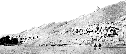 number of Dvarapalas, the heavenly “Guardians of the Quarters,”
and Bodhisattvas (fig.9). So industrious were these artists that some paintings
of Buddha are nearly one hundred feet high. number of Dvarapalas, the heavenly “Guardians of the Quarters,”
and Bodhisattvas (fig.9). So industrious were these artists that some paintings
of Buddha are nearly one hundred feet high. .
Fig.8: Middle and southern groups of Caves
of the Thousand Buddhas at Tun-Huang (Dunhaung) in western China, with Buddhist
paintings and inscriptions from 4th-9th centuries AD (Stein 1912).
Preservation of such works throughout the Silk Road cities offers precious
insights into their varied religious traditions, symbols, and legends. At
Dandan-Uiliq and Endere, Stein uncovered a number of paintings depicting
both Buddhist and Hindu deities, including Ganesha, the popular elephant-headed
Hindu god of wisdom. At the Caves of the Thousand Buddhas, Stein documented
an ancient silk painting depicting King Vaisravana, Buddhist god of Wealth
and patron god of Khotan, moving on a cloud across the ocean with his divine
hosts. At left, a demon attempts to shoot an arrow at Garuda, half-man half-bird,
who flies to the safety of heaven. In Buddhist Khotan temples, depictions
of a local rat-headed divinity were discovered that, as initially described
by Hsüan-tsang, represented the story of how rats helped Khotan’s
king repel a Hun invasion by destroying their horse harnesses. Another story
told through art is a painting of the Chinese princess who introduced silk
manufacture (sericulture) to Khotan.
House-dwellings and associated artifacts:
Stein, in excavating many towns of the ancient Khotanese, preferred to dig
out the more deeply buried structures, as the sands protected them and their
contents from the elements as well as looters. Houses and temples were built
of sun-dried bricks and clay, due to the lack of stone in the Khotan region.
Wooden beams and poles incorporated into the walls and roofs for support
were often the first remains found sticking out of desert sands.
Both local
life and long-distance commercial contact with China are reflected in these
household remains. Everyday items include pottery, and dyed cotton, silk,
and woolen fabrics with designs showing both eastern and western influence.
At Lou-lan, Stein found both polychrome silk and damask fragments revealing
2000-year-old Chinese manufacturing techniques; and tapestries of wool with
a style “unmistakably Hellenistic,” one with a head of the Greek
god Hermes (Stein 1933).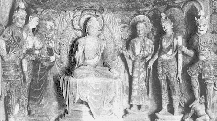
Fig.9: Sculptured group in Mogao Cave,
one of the Caves of the Thousand Buddhas at Tun-huang, showing Buddha surrounded
by Dvarapalas (guardians) and Bodhisattvas (saints) (Stein 1912).
Other finds included leather shoes, animal bones, bone spoons, and wooden
horse combs. Inside household structures at Niya, Stein found tatters of
antique rugs, silk and woolen fabrics, glass, pottery and metal fragments,
agricultural tools, chopsticks, and wooden furniture such as an elaborately
carved armchair with lion-claw legs and armrests in Hellenistic style. Leisure
activities are indicated by remains of musical instruments such as guitars,
and multitudes of sheeps’ knuckles, painted red and yellow, that were
used as dice.
Evidence for commerce with China consists of coins, delicate laquered ceramic
wares, finely woven silk, green and yellow glass, and porcelain sherds with
Chinese seals on them. Both Chinese and local coins were plentiful at Endere,
Khotan, Aksipil, Hanguya, Kara-dong, and Rawak. Local coinages displayed
the bilingual nature of business, with one side printed in Chinese and the
other in Kharoshthi. Most Chinese coins, with their distinctly square-holed
centers, date to the T’ang dynasty (AD 618-907; fig.28). Another clue
that the Khotan region flourished for centuries in the 1st millennium AD
is the abundance of precious stones. Jade was cherished and used, among other
ways, as seals that the inhabitants of Khotan ceremoniously touched to their
brows before opening letters.
Clay pottery and figurines ranging from plain coarse-ware to elaborately
designed effigy bowls were abundantly produced in all shapes and sizes. At
Niya, Stein found an intact pottery jar three feet in diameter. Effigy bowls
and other pots were often decorated with appliqué masks of terra cotta
depicting people, animals, and mythological beings. Handles, spouts and figurines
were also often intricately moulded into realistic or mystical animals .
Agricultural artifacts and features were discovered near many of the houses.
At several sites, shrivelled, bleached trunks of long-dead poplars, willows
and fruit trees protruding from the desert sand indicate the use of ancient
orchards. In a Karagong ruin, Stein discovered the remains of ancient
agricultural goods such as tarigh (millet), wheat, rice, oats, roots, and
dried black currants. To support such agriculture, complex irrigation works
were needed; their gradual abandonment led to the demise of Dandan-Uiliq,
Niya, Endere, and neighboring towns through the Tarim Basin.
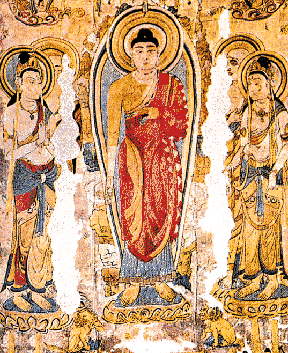
Fig.10: Ancient silk embroidery of Buddha
surrounded by Bodhisattvas, from Tun-huang (Stein 1912).
Inscriptions: A wealth of information
has come to light from the abundant writings found throughout the Khotan
region. First found by Hedin at the Khotan sites, and later a focus of
Stein’s investigations from Khotan to Tun-huang, the texts represent
a number of writing systems or scripts whose succession or co-existence in
Turkestan helps illuminate this little understood yet literate region (fig.11).
Aramaic: Several scripts found in the
Tarim Basin developed out of Aramaic, a Semitic alphabetic writing system
containing 22 consonants and no vowels, that was developed by Canaanite tribes
(Hebrews, Phoenicians, Aramaeans) from 2000-1000 BC. By 800 BC, the Phoenicians
had lent their highly useful alphabet to the Greeks, their trading partners,
who in turn modified and adopted it to their own language. Hebrew was and
has remained more of a secondary, scholarly language (until its recent
re-adoption in the modern state of Israel). Aramaic, meanwhile, became an
international language during the 1st millennium BC and the root of many
new languages, as it was carried with travellers and traders from the eastern
Mediterranean spreading east, south, and north.
Aramaic spread into India and heavily influenced the development of Indic
writing, especially that used in N. India for the Indo-European language
Sanskrit. Emperor Ashoka (273-232 BC), a convert to Buddhism, had his edicts
etched in stone in two local scripts which grew out of Aramaic: Kharoshthi,
a cursive, syllabic script using 252 separate signs, read from right to left;
and Brahmi, a semi-alphabetic script which later becomes the dominant form
in India. Kharoshthi scripts, probably introduced when Persians ruled NW
India in the 5th century BC, were used in Central Asia until the 8th century
AD for commercial and calligraphic purposes. Aramaic writings at Khotan
represented Sogdian, an Iranian dialect from ancient Sogdiana (present day
Samark and Bokhara), and were discovered at Lop-nor and Tun-huang.
At a ruined portion of the Great Wall in Tun-huang, Stein discovered both
Kharoshthi and Sogdian-like Aramaic writtings in a trash pile dated to the
beginning of the 1st century AD. The spectacular find uncovered some of the
earliest known forms of paper and exemplifies the intersection of the East,
West and South at this desert tower.
Sanskrit: The semi-alphabetic Brahmi script
was also used to write Sanskrit documents in the Tarim Basin. Sanskrit
manuscripts representing canonical Buddhist writings were found at Dandan-Uiliq
along with documents in Chinese and a mysterious, previously undiscovered
language (Khotanese).
Tocharian: Another early language in the
Tarim Basin was Tocharian, somewhat controversially considered an Indo-European
language. Sieg and Siegling (1908), who made this identification, also linked
it (based on ancient Greek and Latin historians) with the Tochari of the
upper Oxus River, which may be incorrect. Hedin (V.2, p.69) claimed that,
in 157 BC, the Tokhari (or Tukhari) people migrated from Bulunghir-gol to
west Turkestan and settled in and around Khotan, and that geographical names
such as the town of Tokhla and the Taklamakan Desert are remnants of the
Tocharian language.
Since Tocharian shows no obvious relationship to other Indo-European languages,
it now forms an independent branch of this group and holds a large number
of borrowed words from Turkish, Iranian, and (later) Sanskrit. The Tocharian
literature is heavily Buddhistic in content. Examples of this language written
in Brahmi script have been found in the Tarim Basin dating between AD 500-1000.
There were two Tocharian dialects, A (from Turfan area in the east) and B
(from Kucha region in west but also from the Turfan area). It is possible
that dialect A was a “dead” language, only used in Buddhist
monasteries, while B was more commercially used. Chinese:
The largest collection of Chinese writings found by Stein were Buddhist texts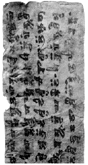 at Tun-huang. He also discovered military and administrative documents at
a number of Tarim sites including Endere, Dandan-Uiliq, and Khotan. Hedin
recovered many Chinese records on paper and wood at Lop-Nor.
at Tun-huang. He also discovered military and administrative documents at
a number of Tarim sites including Endere, Dandan-Uiliq, and Khotan. Hedin
recovered many Chinese records on paper and wood at Lop-Nor.
Khotanese: Khotanese (Saka) was a Middle
Iranian language written in Brahmi script, containing many borrowed words
from the Prakrit (local, Sanskrit-derived) languages of India. There are
two Saka dialects; one seen in many Buddhist and other types of scripts at
Khotan from the 7th-10th century AD, while the other dialect is connected
with Tumshuq. According to Stein, this non-Sanskritic language represented
the local dialect of the Khotan people.
Fig.11: Leaf from a Khotani Saka sutra,
discovered by Sven Hedin (Hedin coll., Stockholm Ethnog.Museum, Montell
1938).
An unnamed Prakrit dialect in Kharoshthi script:
Of all the writings found in the Tarim Basin and eastward, Stein
was most interested in an Indian Prakrit dialect written in the Kharoshthi
script that, he concluded, entered the area during the 2nd century BC conquest
of Khotan by the northern Indian Kushan kingdom. He first encountered this
writing at the site of Niya in January of 1901, in the form of hundreds of
administrative documents written on wooden tablets. Many were wedge-shaped
from seven to thirty inches long, with some rectangular ones up to seven
and a half feet in length. All the variant tablet forms were named in the
ancient writing using bureaucratic categories which Stein, somewhat jokingly,
compared to those of modern India. Some tablets were originally fastened
in pairs to make an enclosed envelope. Sunken sockets filled with clay seals
of Greek figures next to an address written in Kharoshthi marked the outside
of the joined wooden pieces. In a few instances, wooden tablets with double
seals displayed one in Hellenistic style and the other in Chinese characters.
Stein’s interest in the Kharoshthi materials lay in the fact that the
script used in Khotan was exactly like that used around Taxila. This directly
ties early Khotan influences to the Kushan people of the Indo-Scythian dynasty
who ruled over the Punjab (the Indus River zone in Pakistan) during the last
three centuries BC.
Stein, furthermore, found historical evidence in both the 7th century writings
of Hsüan-tsang and old Tibetan texts, which said that Khotan had been
conquered and colonized about 200 BC by Indian immigrants from Taxila (Stein
1904, p.383). Hsüan-tsang learned from early accounts that a number
of chieftains from Taxila (Pakistan) were forced to emigrate to an area north
of the snow mountains to escape the vengence of the king and founded a kingdom
in the Tarim Basin. These are the people, he reports, who introduced Buddhism
to Khotan, and told legends of how the Buddhist divinity Vaisravana
granted the kingdom a dynasty whose first ancestor sprung from the
head of the god’s image.
Taken together, the inscriptions in the Tarim Basin, written on materials
including wood, leather, silk, and paper, provide extraordinary information
about business, politics, and personal life in the ancient towns. One
officer’s report found at Dandan-Uiliq, dated precisely to AD 768, requests
that the people of his town be allowed to pay their taxes late, due to economic
harships from a recent rash of robberies. Another ancient (but undated) document
depicts a military requisition for an animal skin to re-cover a drum, and
feathers to repair arrows. The manuscripts in the local Khotan writing system
from Dandan-Uiliq denote recoveries of debt, bonds for small loans, and reports
from local officers, all dating between AD 781-790. This coincides with the
end of the Chinese T’ang Dynasty’s control over the region around
AD 791, followed by the Tibetan invasion. Likely not a coincidence, maintenance
of the vital irrigation system subsided around the same period, as Chinese
officials in charge of them abandoned their stations. Tibetan texts dated
to AD 719 from Endere foreshadow the Tibetan rise to power.
Another intriguing text centers around Hwi Chao, a Korean monk who grew up
in China and travelled to India via the sea. He ended up living and travelling
in India and Turkestan from AD 713 to 741. Based on his adventures, Chao
wrote The Record to Five Indian Kingdoms, a work widely referenced by other
ancient scholars that provides valuable information on Islamic and Buddhist
distributions in Central Asia at this time. The book had been declared lost
since the T’ang Dynasty, until French explorer Paul Pelliot found a
14-page section of it in a Tun-huang cave in 1908.
The extended Great Wall: During his second
expedition in 1906-1908, Stein ventured as far east as the western gate of
the Great Wall in Chia-yü-kuan. Strategically located with several thousand
miles of mountains to its south, it protects eastern China’s only accessible
entrance from the west. However, at Tun-huang, much further west, Stein noted
Chinese limes, or frontier fortifications, of great antiquity. Stein
describes the guard towers as 30 ft high with bases of 20 square feet tapering
towards their tops (fig.35). Usually, Stein found the adjoining living quarters,
originally built of wood, to be badly damaged by the elements. However, in
some instances, he discovered guard rooms that were buried and preserved
by fallen tower sections .
In one of these initial excavations of the limes, Stein first encountered
written records of the guards on a solid block of wood, painted black and
thickened at one end, with a string attached, On this wooden tablet were
two red Chinese characters. Puzzling Stein and his co-workers, the meaning
of this artifact was realized weeks later after one of Stein’s excavators
recalled a similar item still used in modern armies. He explained how soldiers
from garrisons would carry large conspicuous permits of leave to prevent
confusion and limit the number of soldiers allowed to be away from their
posts at any one time. Along with the ancient permits Stein and his crew
found a wide variety of everyday materials in the guardhouse, including
administrative accounts, pottery jars, wooden combs, broomsticks, wooden
hooks, cross-bows, and arrowshafts. All of this evidence made it clear that
these limes dated as far back as the Han Dynasty (202 BC-220 AD),
as supported later by the date inscribed on an artifact to the third year
of the Chü-shę period in 8 AD.
Interestingly, at the Great Wall extension Stein also found a box fastened
in a manner unmistakably like the triangular wooden Kharoshthi script
“envelopes” of the Niya sites. Here, however, they were three centuries
older and inscribed with Chinese characters. Based on this evidence, Stein
contended that these Chinese limes dated to the T’ien-han period in
the 2nd century BC. He further suggested that these western limes were identical
to the Great Wall. Their purpose, he deduced, was largely for defense against
the Hsiung-nu (Hun ancestors), but also provided the Chinese military a strategic
point from which they could patrol and extend their own territory.
Khotan’s Legacy: Sven Hedin’s
and Aurel Stein’s achievements in revealing early Central Asian history
have enlightened scientific and public communities alike about a large but
little understood area. In spite of great hardships in the Tarim Basin’s
harsh environment (Hedin almost died from dehydration, and Stein lost the
toes on his right foot to frostbite), they persevered to make lasting
contributions, which seem especially relevant today to our understanding
of this region’s history.
Stein and Hedin’s important work has seen surprisingly little follow-up
by modern archaeologists. Within the past 10 years, the search for the lost
cities of the Silk Road has recommenced by investigators using satellite
imagery to detect traces of ancient settlements in the desert. Current dramatic
political events in the Afghanistan/Pakistan region will also no doubt rekindle
widespread interest in its remarkable role as an east-west crossroads, but
make it more difficult to study . Yet the Khotan sites show how positive
cultural exchange between diverse cultures is itself part of the shared
background of the Silk Road region, and may serve as a kind of beacon of
hope in the midst of today’s grave misunderstandings and conflicts in
the mountains and deserts of Central Asia.
.
by William Rust and Amy Cushing
References:
Bergman, Folke 1935. “Lou-Lan wood carvings and small finds discovered
by Sven Hedin.” The Museum of Far Eastern Antiquities Stockholm
Bulletin No. 7. Stockholm, Hasse W. Tullberg’s Boktrycheri,
Esselte AB.
Hedin, Sven 1899. Through Asia. New York and London, Harper
Brothers.
Lane, George S. 1974. “Tocharian Language.” Encyclopaedia
Britannica V.18:467-468. Chicago, Helen Hemingway Benton, Publisher.
Montell, Gösta 1935. “Sven Hedin’s archaeological collections
from Khotan.” The Museum of Far Eastern Antiquities Stockholm
Bulletin No. 7. Stockholm, Hasse W. Tullberg,, Esselte AB.
Montell, Gösta 1938. “Sven Hedin’s archaeological collections
from Khotan II.” The Museum of Far Eastern Antiquities Stockholm
Bulletin No. 10. Stockholm, Hasse W. Tullberg, Esselte AB.
Reischauer, Edwin and John Fairbank. 1960. East Asia The Great
Tradition. Boston, Houghton Mifflin Co.; Tokyo, Charles E. Tuttle
Co. Inc.
Stein, M. Aurel. 1904. Sand-Buried Ruins of Khotan. London,
Hurst and Blackett, Limited.
Stein, M. Aurel. 1912 (repr.1999). Ruins of Desert Cathay. Personal
Narrative of Explorations in Central Asia and Westernmost China.
New Delhi, Madras, Asian Educational Services.
Stein, M. Aurel. 1933. On Ancient Central-Asian Tracks. New
York, Pantheon Books.
Sullivan, Michael. 1979. The Arts of China. Berkeley, University
of California Press.
Thapar, Romila 1966. A History of India. Middlesex, Penguin
Books.
Turner, Eric, Ruth Barbour, T. Julian Brown, Ray Nash, Donald Anderson, Ralph
Pinder-Wilson, Chiang Yee, Won-Yong Kim. 1974. “Calligraphy.”
Encyclopaedia Britannica V.3:661-670. Chicago, Helen H.Benton.
Wild, Oliver 1992. “The Silk Road.” http://www.
ess.uci.edu/~oliver/silk.html.
Wilhelm, Richard 1929. A Short History of Chinese Civilization.
London, George G. Harrap and Co. Ltd.
Wright, Thomas 1901 (transl.). The Travels of Marco Polo. London,
George Bell and Sons.
This article appears in Vol.3, No.1 of Athena
Review.
.
|
|