|
Gregory Deyermenjian, The Explorers Club
The following account documents the 1999 Paititi/Pantiacolla
Expedition in Peru led by Gregory Deyermenjian, veteran of several Andean
expeditions as a member of the Explorers Club, who sponsored the
project. The 1999 Expedition found and documented the furthest signs
of an ancient Incan presence directly north of the Incan capital city of
Cuzco, Peru. .
Our
goal was to pick up where we had left off in 1993. In that year we had gone
beyond the Incan barracks-like ruins at the Meseta (plateau) of Toporake,
following the lone Incan trail--that we had encountered upon our reaching
Toporake in 1989, and that had been previously, and independently, sighted
from the air by Peru´s foremost living explorer, Dr. Carlos
Neuenschwander--that headed off from there toward the vast and largely unexplored
Meseta de Pantiacolla. We had reached a point--after weeks of being
set upon by rain almost every day--from whence, because of the vast distance
from Cusco, we had to turn back: we had used up our time, energ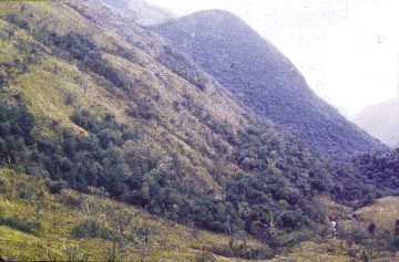 y, and supplies
in just reaching that area in the southern reaches of the Meseta. We documented
by GPS our ultimate point reached, a point just beyond a fine Incan retaining
wall just above the trail. At that moment we realized that it may be futile
to try again to reach and penetrate this distant region without a helicopter
to at least transport us to that point, from which we could begin
fresh. y, and supplies
in just reaching that area in the southern reaches of the Meseta. We documented
by GPS our ultimate point reached, a point just beyond a fine Incan retaining
wall just above the trail. At that moment we realized that it may be futile
to try again to reach and penetrate this distant region without a helicopter
to at least transport us to that point, from which we could begin
fresh.
Fig.1: Uppermost beginning of the Río Timpía,
in highlands leading down into cloud forest (photo: Gregory
Deyermenjian).
In 1994 we began our official association with Dr. Neuenschwander,
joining forces in the organization "Asociación Cultural Exploraciones
Pantiacolla"; but, in that year and 1995 and 1996 we failed to raise enough
to rent a helicopter ($2000 per hour!), and so, each of those years we explored
other adjacent areas on foot. Finally, this year, Heinz von Matthey, a German
film maker, supplied enough money for five helicopter hours.
And so we set off from Cusco,--campesinos and mountain and jungle
experts Paulino and Ignacio Mamani, Heinz von Matthey, Lima cameraman Pedro
Neira, Cusco transportation entrepreneur and Paititi aficionado Marco Rozas,
cook "Ide", and a five man helicopter crew from HeliSur. We overflew various
exploration zones, getting an exceptional feel for these largely uncharted
areas. The helicopter crew had by now picked up on our enthusiasm, and had
read the "Paititi" books we had with us--especially those of Dr. Neuenschwander,
who had identified one zone in particular that, from his examination of his
superbly clear aerial photographs, he believed may contain important and
large structures--and the crew themselves acted like Paititi aficionados,
excitedly pointing out from the cockpit various natural features famous in
the Paititi legend, such as ˇel Cerro de Cinco Puntos! ("the Mountain
with Five Peaks!) and ˇla Laguna Cuadrada! ("the Rectangular Lake!").
It had developed into as perfect a team situation in the field as we could
have possibly desired. (And we had been extremely lucky that this HeliSur
helicopter, usually based in Lima or Iquitos, had made an unrelated trip
to our Cusco just as we arrived there, desirous of finding a helicopter on
which to spend the $10,000 cash I had brought from Boston.)
After
gathering very useful geographical/topographical intelligence for three days,
Paulino and Ignacio and myself were dropped off at the headwaters of the
Río Timpía (figs.1,2). What followed was 15 continuous days
of nonstop walking, slipping, and sliding. Before our descent on foot from
the highlands to the cloud forest and swift-flowing river below us, intending
to go beyond our furthest point reached in ´93, however, we documented
that retaining wall, the last "fine" I ncan structure furthest from the Incas'
ancient capital city of Cusco. It overlooks a portion of the long, appearing-
and- then- disappearing Incan trail that we had been following for many years,
that begins way down south in the Cordillera (long chain of mountains and
highland) de Paucartambo, and that appears to then dip down into cloud forest
and selva (jungle), heading toward some as yet unknown site. (For some
reason, none of the photos I had excitedly taken of this retaining wall in
1993 ever came out in the developing of the film.) ncan structure furthest from the Incas'
ancient capital city of Cusco. It overlooks a portion of the long, appearing-
and- then- disappearing Incan trail that we had been following for many years,
that begins way down south in the Cordillera (long chain of mountains and
highland) de Paucartambo, and that appears to then dip down into cloud forest
and selva (jungle), heading toward some as yet unknown site. (For some
reason, none of the photos I had excitedly taken of this retaining wall in
1993 ever came out in the developing of the film.)
Fig.2: Map of the Río Timpía, location of the Inca
stone retaining wall first seen in 1993, and Laguna de Angel with further
evidence of Inca stonework (Gregory Deyermenjian).
We began our descent, following the trail along the side of an
increasingly heavily cloud-forested hillside. Soon we had to abandon our
attempt to follow the trail itself, as the 500 years of accumulated debris,
vegetation, fallen logs, landslides, and maleza (thick undergrowth) made
it more difficult to try and cut our way along the trail than to descend
to the river directly below and to then walk and jump from one slippery rock
or log to another, and to wade repeatedly through the icy cold water of the
headwaters of the Río Timpía. It was like a days-long obstacle
course, and the mental concentration that had to be constantly maintained
to avoid a nasty fall seemed to put one into a kind of trance, just living
from one rock, one foot placement, to another, over and over.
There
were three pongos, impassible deep gorges, which separate even this, the
upper Timpía, from the outside world, --(never mind those pongos further
downriver which could even be more formidable obstacles, allowing the Machiguenga
and KugaPacori there, some of whose chozas [huts] we saw while flying over
in helicopter, to live in a tr uly isolated and unreachable part of the world
into and beyond 1999, and us with no chance of ever landing in such precipitous
territory)-- which (the pongos) we had to climb up over and around
using ropes. It was too much for me, but, as I had no choice, somehow I did
it. uly isolated and unreachable part of the world
into and beyond 1999, and us with no chance of ever landing in such precipitous
territory)-- which (the pongos) we had to climb up over and around
using ropes. It was too much for me, but, as I had no choice, somehow I did
it.
Fig.3: Inca stone retaining wall found in 1993, now partly
cleared of vegetation (photo: Gregory Deyermenjian).
We would typically make camp by the river, then climb up the next
day, without our backpacks, cutting our way into the thick bosque de nubes
(cloud forest) to seek signs of the trail. Very often, at a certain consistent
altitude above the river, we would finally uncover some pirqas (flat slate
stones, piled one upon the other) indicating a roughly made (muy rústico)
retaining wall above what had been a trail. We climbed finally to the
top of the highest peak in the area, which, we saw, lay astride a pampita,
an atypically flat area, that would make a grand landing area for a helicopter
at some future time. We noted that the trail appeared to continue on for
an indeterminate distance downstream, ever downstream; and that we would
probably need weeks and weeks more time to ever reach its end on foot. After
over a week of being in that cold, wet, raging water and dense cloud-forested
dungeon, we had to escape. We documented as many positions as we could with
GPS (Global Positioning System), then began the days long climb back uppriver,
back over the pongos, until we finally reached the high alturas where
the Río Timpía was nothing but a trickle below us.
We headed south, walking with our packs at 3800 meters altitude, and
stayed a night with a group of vaqueros (cowboys) tending their hardy half-wild
cold weather cattle. Paulino became their best friend through working with
them in corraling their cattle and pushing the recalcitrant and ornery horned
beasts up over the peak above us, and sharing coca leaf and trago
(strong sugar cane liquor), and one of their loosened tongues told us of
an enchanted lake, in an area of terrible meteorological difficulties, where
there were Incan ruinas, in a higher area to the northwest. The last thing
I wanted to do was head off in that direction, but I realized that if I
didn´t follow this lead, I would wonder about it, and so regret it,
all year. The tale coincided with that told us in 1986 by a Machiguenga forest
Indian, "Angel," just as we reached the peak of the previously unclimbed
"Apu Catinti," about how when his group had suddenly fled their valley along
a tributary of the tropical Río Yavero in 1964, determined to once
and for all escape the slavery that had been imposed upon them by settlers
who had come from outside the area, they first passed through an unbearably
frigid region where they almost all died of hunger and cold astride a strange
lake with a shape that, as it was described, seemed like a figure eight.
The lake would be found north of Toporake, and was supposed to have Incan
stones around it. On our topographical map, made from aerial reconnaisance,
we saw a large lake in the area through which the Machiguenga would have
passed, that appeared to be uniquely shaped.
So, we headed there. And, in fact, as soon as we left the massif upon
which the cattlemen were, and then climbed up onto the next massif to the
northwest, the hailstones, rain, and snow began. For two full days we walked,
having to huddle in shallow caves early each afternoon as the hail and rain
hit us, waiting out the worst of it. I thought that my feet, perpetually
wet from boots that had never dried out since walking every day the
previous week through the waters of the Río Timpía, were about
to freeze right off. It was the most physically drained I´ve ever been,
being there, trying to keep on putting one foot in front of the other to
reach the lake.
But,
finally, using my GPS and an aerial survey map and Paulino´s seemingly
preternatural instincts--and because I had no choice but to keep following
Paulino and Ignacio before me-- we arrived, and everything fit. The lake
was shaped like an "8", and had certain Incan remains in the form of pirqa
retaining walls and "plataformas" (low stone raised areas from which to view
the sun), and was subject to the hail and snow and rain that had nearly been
the demise of the Machiguenga more than thirty years before. The evidence
of an ancient Incan presence mark it as the furthest Incan site yet to be
identified directly north of Cusco. It appeared to Paulino´s sharp eyes
and well tuned senses that these types of remains would continue on further
to the northwest, and that there was a c ertain lay-of-the-land that would
indicate a very possible connection between this area and that of the peak
and retaining walls and trail that we had earlierdocumented to the east and
northeast, in the cloud forests lining the upper Río
Timpía. ertain lay-of-the-land that would
indicate a very possible connection between this area and that of the peak
and retaining walls and trail that we had earlierdocumented to the east and
northeast, in the cloud forests lining the upper Río
Timpía.
Fig.4: Laguna de Angel, reached in 1999 in a high, cold area
NW of Río Timpía headwaters (photo: Gregory
Deyermenjian).]
We named the lake "Laguna de Angel," then began the long way back.
The going was sheer torture, with the distances being more vast than on the
coming (since we had been brought by helicopter to that starting point above
the headwaters of the Timpía), but with my energy and "ánimo"
(spirit) having been all but totally spent in the explorations. But finally
we arrived, four days later, at 2 A.M. And I was very happy to be there in
Cusco, just as I am very happy to be in Massachusetts.
For future expeditions, our strategy shall be this: save a few hours
of helicopter time, then, when the explorations are complete, when we´ve
used up all our supplies and "fuerza" (strength) in the explorations, use
the satellite phone we now have at our disposal to call our loyal, enthusiastic
helicopter crew, give them our latitude and longitude, and ride back to Cusco
in comfort and style...
References: Updated information on Expedition 2000: The
Search for Paititi and the Lost Realm of the Incas
Related discoveries by Deyermenjian and his colleagues from
previous expeditions are described in "The Petroglyphs of Pusharo,"Athena Review, Vol.2, no. 3 (2000).
This article appears in Vol.2, No.2 of Athena
Review.
.
|
|