Athena Review Image Archive ™
Mississippi River channels
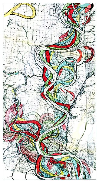
Holocene channels in the Mississippi Rivers (after Fisk 1944).
This map shows the range of abandoned and active channels in the Mississippi valley which have accumulated in the Holocene (recent) period.
The lower Mississippi River below Cairo, Illinois becomes a meandering river which frequently changes its course, creating new channels by cutting across narrow spits of land. The meanders have predictable patterns, where the inner bank, due to higher energy water flow, erodes as a “cut bank” and the outer bank is built up as a point bar, as the river dumps its heavier sediments going around a curve. During floods, the lighter sediments are also deposited along levees. These topographic features remain visible after the river has found a new channel.Before they are deeply covered by sediments, the point bars and levees of abandoned river channels are easy to see in aereal photos.
Beginning
in the 1940s, using aerial photos combined with numerous core samples,
the geologist Harold Fisk mapped the Holocene courses of the
Mississippi back for about 10,000 years to the end of the Pleistocene
period at the last ice age (Fisk 1944). Fisks’s initial
study has been continued and refined to the present day by other
geologists, with the same techniques applied to many rivers around the
world. Many of the abandoned channels contain archaeological sites
which were once on active rivers (Saucier
refs).
With reference to paleontology and geology, the point bars,
levees, and other features of ancient river channels such as these can
also be reliably mapped in cross section in sedimentary rocks, going
far back in geological time. Thus, if you took the entire lower
Mississippi Valley mapped by Fisk for the last 10,000-12,000
years and turned it on its side, it would represent a vertical
section (or geological strata) about 1000 miles long from north to
south and 100 miles wide east to west, and a few dozen meters in depth.
Much earlier meandering rivers can also be traced, such as many
examples of ancient point bars visible in exposed strata of the
Permian Basin of Texas and Oklahoma, as well as in South Africa and
Russia.
References
Fisk, Harold 1944. Geological Investigations of the Alluvial Valley of the Lower Mississippi River.
Copyright © 1996-2020 Rust Family Foundation (All Rights Reserved).