Athena Review Image Archive ™
Map of Middle and Late Permian sites in western Russia
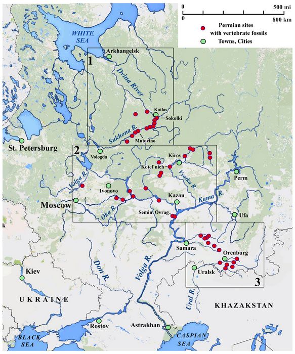
Middle & Late Permian sites in western Russia (Golubev 2000,fig.6; Athena Review).
The Tatarian stage of the Permian in western Russia (ca. 265-255 mya) represents a terrestial setting which was crossed by numerous rivers. This stage, up to 200-250 m in thickness, and mainly exposed in in the watersheds of rivers, is composed of red-bed (variegated) clays, siltstones, sandstones, marls, dolomites, and limestones containing only non-marine fossils including bivalves, plants, insects, and vertebrates.
Dozens of large Tatarian fossil sites haved been mapped and intensely investigated along the drainages of the North Dvina, Volga, and Ural Rivers. This map shows these three major river drainages in western Russia, with numerous Middle and Late Permian fossil sites shown as red dots in three boxes. Site locations are taken from Golubev (2000).
(1) Top box: Dvina River, with Sakhoma River.
(2) Middle box: Volga River with tributaries, Oka and Kama Rivers.
(3) Bottom box: Ural River.
Reference:
Golubev, V.K. 2000. The Faunal Assemblages of of Permian Terrestial Vertebrates from Eastern Europe. Paleontological Journal 34, suppl.2.
Copyright © 1996-2020 Rust Family Foundation (All Rights Reserved).