Athena Review Image Archive ™
Permian and Mesozoic zones in western Russia
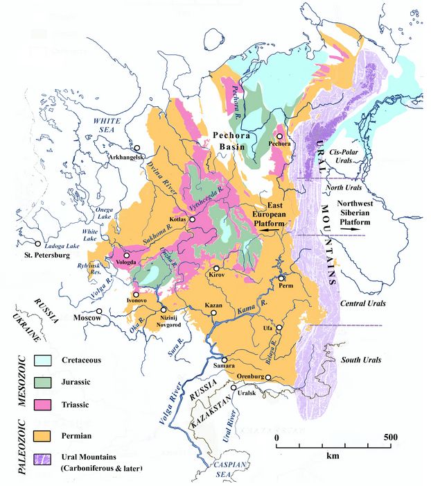
Permian and Mesozoic zones in western Russia (Athena Review).
This geologic map shows the locations of Permian and Mesozoic
zones in western Russia. The Mesozoic era, including the Triassic,
Jurassic, and Cretaceous periods, are specifically identified by
period, as is the Permian. The Ural Mountains, meanwhile, are shown
with undifferentiated "Carboniferous and Later" identification.
The
geologic area from St. Petersburg to the Ural Mountains (an area now
known as the East European Platform), flanked on the north by the
Baltic and Berents Sea coastline, was first studied in detail in the
early 19th century. Permian strata along the North Dvina River,
which flows north into the White Sea at Arkhangelsk, were initially
identified by the Scottish geologist Roderick Murchison in 1840-1. This
came in the process of defining the geologic interval between the
Carboniferous and Triassic as the Permian period, named after the
ancient kingdom of Permia (Murchison et al. 1845).
On
ascending the Dvina River from Arkhangelsk, Murchison and his
colleagues recognized Permian formations in riverbank exposures,
sometimes comprising alternating layers of white gypsum and reddish or
oxidized sandstone, representing riverine deposits overlying marine
limestone strata.
References:
Murchison,
R. I., E. de Verneuil, and A. von Keyserling, 1845. The
Geology of Russia in Europe and the Ural Mountains. London, John
Murray.
Copyright © 1996-2020 Rust Family Foundation (All Rights Reserved).