Athena Review Image Archive ™
Map of the Roman Aqueduct to Nîmes
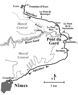
Map of the Roman aqueduct to Nîmes (after Bromwich 1996).
At
least 44 million gallons (20,000 m3) of water were brought in daily to
the Roman town of Nemausus (Nîmes) via an impressive aqueduct system of
50 km from springs at the Fountaine d'Eure in Uzčs. Built by Roman
engineers throughout the 1st century AD, the aqueduct route went around
the east side of the higher Massif Central, following a total gradiant
of about 17 meters through a series of some 35 km of tunnels. The
Gardon valley was spanned with aqueduct bridges, the most intact
remaining today at Pont du Gard.
Other sections of the aqueduct
may be sen at Bornegre, where a 17 meter portion survives where the
channel first emerged from tunnels. Near Vers is a fragmentary 700
meter bridge section called Pont Rue. Near Pont du Gard is a smaller
bridge remnant at Pont de Sartanette. Two 60-meter tunnel sections may
also be seen at Sernhac, where ancient pickaxe marks are still visible.
When the water reached Nîmes, it was stored in a large holding tank called a castellum, from which it was piped to all parts of the city.
.....Copyright © 1996-2019 Rust Family Foundation (All Rights Reserved).