Athena Review Image Archive ™
Jerash: plan of Roman site
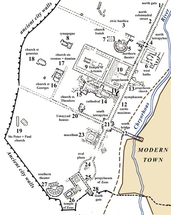
Jerash: plan of the ancient site (Athena Review Image Archive)
Jerash (Roman Gerasa), located 34 km north of Amman in northern Jordan on the Chryorhoas River, was a major Hellenistic and Roman site between the late 2nd century BC and early 4th century AD. The town was revived during the early Byzantine era of the 5th and 6th centuries, then had a brief Umayyad occupation before being abandoned after major earthquakes in the 8th century AD.
The site was first identified in 1806 and major excavations began in 1925-1934. The west side of the ancient town is now preserved as an archaeological monument. The portion east of the river lies under the modern town and remains unexcavated.
The town plan of Jerash dates from the early Roman era, with a cardo maximus or principal north-south street bisecting two decumani or east west streets. The cardo ran parallel to the Chrysorhoas River, crossed by three bridges. Beneath it was an underground sewage system.
By AD 75, the wall surrounding the town was completed, with 101 towers spaced at 17-22 meter interals. The walls were rebuilt and thickened in the 4th century AD. There were six entrances, including the main North and South Gates. A number of churches and a synagogue were built in the Late Roman and Early Byzantine periods.
The features labelled in this plan have the same numbers corresponding to those on the satellite photo shown on this site.
[source: Aubin, Melissa M. in The Oxford Encyclopedia of Archaeology in the Near East (1997), vol.3, pp. 215-219].
,Copyright © 1996-2020 Rust Family Foundation (All Rights Reserved).