Athena Review Image Archive ™
Map of the first voyage of Columbus in the Antilles (1492)
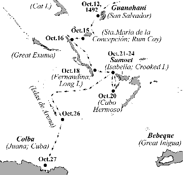
Map of Columbus' route in the Antilles in the first voyage (Athena Review Image Archive).
Columbus
first landed among the Arawakan-speaking Taino in the southeast
Bahamas, called the Lucayos (Leeward Islets) by the Spanish. Columbus'
Journal for Oct. 13, 1492 notes "To the first island I gave the name of
the blessed Saviour [San Salvador]... But the Indians call it Guanahaní..." (Taino for "iguana").
Leaving
Guanahaní on October 15 with native guides aboard, the Spanish ships
passed Rum Cay which they named Santa Maria de la Concepción. The next
four days (Oct.16-19) were spent at Fernandina, where Columbus
witnessed the trading skills of the native Taino. A short distance east
was the island called Samoet
(Isabella, now Crooked Island), where the Spaniards anchored from
October 20-24. After briefly sailing west, on Oct. 25-26 they ran into
shoals (the Islas de Arena), and turned south. On Oct. 27, Cuba (Juana)
was sighted and the Spaniards spent the next five weeks (Oct.28-Nov.5)
along its northeast coast.
This map is based on information from Morrison (1942).
.Copyright © 1996-2019 Rust Family Foundation (All Rights Reserved).