Athena Review Image Archive ™
Tierra del Fuego: map of eastern side
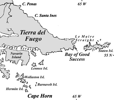
Tierra del Fuego: map of eastern side (Athena Review Image Archive).
Tierra del Fuego was first recorded in 1520 during the voyage of Ferdinand Magellan. Named for the fires (fuego) lit along the shore by native peoples, the foggy, inhospitable region was crossed again by voyages of the 17th and 18th centuries including those of Drake and Cook.
Several different language groups living in
the cold, foggy region of Tierra del Fuego included the Yahgans, the
Ona, the Alacaluf, and to the north, the Tehuelche. While Magellan's
chronicler Pigafetta had collected a vocabulary of Tehuelche words in
1520, little detailed information was known about the Fuegians prior to
the early 19th century voyage of the British survey ship H.M.S. Beagle, which returned three Yahgans to their homeland from a visit to England.
The crew of the Beagle
included Charles Darwin, whose journal for Dec. 17, 1832 records the
ship entering Le Maire Straight, then hugging the Fuegian shore with
the rugged outline of Staten Island seen amid low clouds. Anchoring
that afternoon in the Bay of Good Success, a group of Yahgans met with
the captain. The scene, including an elder man and several youths
wearing face and body paint, was described by Darwin as an amazing
confrontation of different cultures.
Copyright © 1996-2019 Rust Family Foundation (All Rights Reserved).