Athena Review Image Archive ™
Rivers Seen From Space: Río Sao Francisco at Bebedouro, Brazil
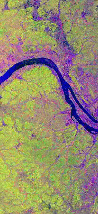
Rio Sao Francisco at Bebedouro (NASA/JPL image P-44734).
This
SIR-C/X-SAR radar image of the Rio Sao Francisco in eastern
Brazil shows an area 16.5 kilometers wide, centered at 9 degrees south
latitude and 40.2 degrees west longitude. The region was originally
settled by speakers of Tupi, Ge, and Arawak languages. After 1600 a
number of Dutch trading colonies were established along the nearby
Caribbean coast.
The NASA/JPL image, a composite view taken from
the space shuttle Endeavour on April 10 and October 1, 1994, has been
used to help estimate the size and productivity of planting areas. Such
projections are made difficult in Brazil by prevailing cloud cover
during the rainy season (November through April). The SIR-C radar
apparatus effectively overcomes these difficulties, by literally seeing
through the clouds. The floodplains of the Rio Sao Francisco lie within
a semi-arid region of Brazil. Some planning estimates have shown that
up to 10 times more land could be used for local agriculture, given
more efficient use of irrigation methods.
In this composite
image, red represents the data acquired on April 10, 1994, and green
represents imaging on October 1, while blue corresponds to the
ratio of the two data sets. In April, at the end of the rainy season,
the area was covered with vegetation , while in October the run-off
channels of the hilly terrain are much more visible, due to the lower
soil moisture of the dry season.
Copyright © 1996-2019 Rust Family Foundation (All Rights Reserved).