|
Metaxia Tsipopoulou Archaeological Museum, Agios Nikolaos
History
of Research at Petras: Fieldwork conducted in the region by two of the
greater names in Minoan archaeology, Nikolaos Platon and Costis Davaras,
raised the probability that an important Minoan settlement was to be sought
in the area of the modern town of Siteia. Chief indicators were the two religious
sanctuaries overlooking the Siteia plain, both active in the Protopalatial
and Neopalatial periods (19th - 15th cent. BC). It is known from elsewhere
in Crete that during the Bronze Age such sanctuaries were connected to major
administrative centers, frequently palaces. The Piskokephalo sanctuary was
considered exceptional by v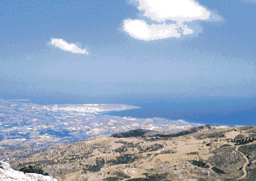 irtue of its low altitude, since it failed to
answer to the then prevalent definition of a peak sanctuary. Yet its finds
place it among the most significant of such sites: several terracotta models
of shrines capped with horns of consecration, a surprising number of large
figurines, both male and female, as well as the usual multitude of small
figurines depicting human figures and animals. irtue of its low altitude, since it failed to
answer to the then prevalent definition of a peak sanctuary. Yet its finds
place it among the most significant of such sites: several terracotta models
of shrines capped with horns of consecration, a surprising number of large
figurines, both male and female, as well as the usual multitude of small
figurines depicting human figures and animals.
Fig.1: View of Siteia Bay from the peak sanctuary of Prinias (photo:
M. Tsipopoulou).
During the 1950s, a series of Neopalatial (17th-15th cent. BC) finds were
made by chance, as new roads were opened up in this isolated part of the
island. At Achladia, Zou, Prophitis Ilias, and Klimataria, Platon excavated
examples of a type of structure that were known in the specialized literature
as "villas," "country houses," "mansions," or "houses of local chieftains."
They were understood as local agricultural centers, consisting of a mix of
refined architecture, such as representative areas and domestic shrines,
and functional features, including storage and industrial production areas.
Already in the 1920s and 30s, larger examples had been excavated in central
Crete at Vathypetro, Sklavokampos, Amnisos, and Nirou. Clearly, the Siteia
area was organized in a manner similar to that of other economic and political
centers in Neopalatial Minoan Crete, with the notable exception that no palace
had as yet come to light. Despite the clues offered by the sanctuaries and
the "villas," none of the archaeologists then active in eastern Crete deemed
it worthwhile to search for such an architectural unit. The Siteia Bay area
was too small, it was thought, to have required such a center, and the previously
known Minoan palaces at Malia, Gournia, and Zakros (fig.2) rendered
its existence even more unlikely. Zakros formed, it was argued, the palatial
focus of eastern Crete, particularly given the absence of a palace at
Palaikastro, a site which offered far better arguments than the Siteia area.
The excavator of Zakros, Platon, reconstructed the economic and political
organization of eastern Crete as centered on his site, to which the "villas"
were tied. These housed the local chieftains who answered to Zakros, an
arrangement rendered necessary by the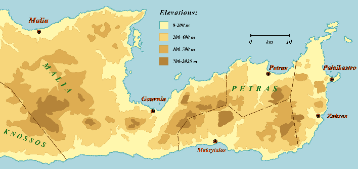 distance and the harsh topography,
and the attendant difficulties in communication. distance and the harsh topography,
and the attendant difficulties in communication.
Fig.2: Map of eastern Crete showing Neopalatial polities and palace
sites (after M. Tsipopoulou). In this
intellectual climate, the coastal area of Siteia was considered unpromising,
a mere vista on the road to the great sites further east. It was forgotten
that already in 1900, R.C. Bosanquet had spent three days sinking a number
of trenches on a low hill opposite the modern town of Siteia known as "Petras."
A short report witnesses to interesting finds, leading the excavator to conclude
that here lay the gateway to the Eastern Mediterranean, the stepping-off
point for Minoan ships trading with the East. Yet Bosanquet abandoned the
site, believing it to be too poorly preserved to warrant further attention.
He continued on his road eastwards, destined to discover and excavate
Palaikastro, which was to become the crowning achievement of his career.
When, in the early 60s, the palace of Zakros was discovered, and the spectacular
finds argued heavily in favor of seeing this site as the gateway, the fate
of Petras appeared sealed. The hill, however, was covered with walls piercing the surface of the soil,
and with a dense coverage of sherds and other artifacts. After a visit in
1983, the present author decided to undertake a trial excavation in 1985.
The topography of the hill, having a large flat plateau on the northern edge
of a long ridge, and a series of terraces on the lower hill as it slides
down onto the valley floor, suggested that a major structure was to be sought
on the plateau. The trial trenches were placed
further down, on one of the terraces, so as to allow the archaeologists to
uncover the stratigraphical sequence of the site before turning their attention
to the main feature. A survey in the second season indicated that the Petras
site consisted of four separate concentrations of finds: the main settlement
on Hill I; a secondary, mainly later occupation on Hill II; scattered finds
on the ridge south of t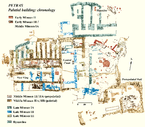 he site, Hill III; and a series of later Minoan
chambertombs cut into the side of Hill IV. After 17 years of excavation and
study, it is evident that the administrative center for the area is not to
be sought further east, but that it lies on Hill I, at the palace of Petras. he site, Hill III; and a series of later Minoan
chambertombs cut into the side of Hill IV. After 17 years of excavation and
study, it is evident that the administrative center for the area is not to
be sought further east, but that it lies on Hill I, at the palace of Petras.
Fig.3: Plan of the Palace at Petras (M.Wedde, M. Tsipopoulou, and
M. Klontza).
The Palace Plan: The palace of Petras (fig.3) is, in fact, two palatial
buildings, the one superceding the other on the same emplacement. Continuity
throughout is attested by the constant north-south orientation of the Central
Court (fig.3), around which, as is customary with Minoan palaces, the entire
structure was organized from its Middle Minoan IIA (early 19th cent. BC)
inception until the final destruction in Late Minoan IB (1480-1425 BC). The
building suffered two significant intermediary destructions, one at the end
of the Protopalatial period (Middle Minoan IIB, early 17th cent. BC), the
other possibly connected with the Santorini eruption towards the end of Late
Minoan IA (ca. mid-16th cent. BC). Each reconstruction of the west wing
re-employed the system of six west-east axis walls that characterized the
first construction. The significant feature of the Petras palatial plan is
that the Central Court is not surrounded by a separate wing on each side;
the sole wing that can be followed throughout the life of the building is
the west wing. On the north side, a large storage facility was constructed
in Late Minoan IA (1600-1500 BC), when the bedrock was cut back to create
the necessary flat surface. What existed here before remains unknown; the
only indications available today concern the Prepalatial period (2900-2000/1900
BC). To the east of the Central Court there was a narrow stoa-like construction
facing a large open space limited to the east by the cyclopean-like wall
that delimits the plateau. The south side remains an enigma. Remains from
the Protopalatial period in the southeast corner could suggest that a south
wing was part of the original plan, but to date nothing has come to light.
 The earlier
Protopalatial court measures ca. 6.5 H 18 m and was originally enclosed by
substantial walls on all four sides. The court was covered with plaster of
fine quality. A substantial drainage system removed the rain water from the
roof, one branch running along the western edge of the court, a second running
eastward as a channel cut into the bedrock. The earlier
Protopalatial court measures ca. 6.5 H 18 m and was originally enclosed by
substantial walls on all four sides. The court was covered with plaster of
fine quality. A substantial drainage system removed the rain water from the
roof, one branch running along the western edge of the court, a second running
eastward as a channel cut into the bedrock. Fig.4: View of the earlier (Protopalatial-Late Minoan IA) and the
later (Late Minoan IB) central courts from the north-northeast (photo:
M. Tsipopoulou). At the western half of the north
wall of the court, a monumental staircase (fig.5) with fine plaster surface
functioned as the main entry into the building complex. In the Late Minoan
IB phase (15th cent. BC), the court was reconstructed in reduced dimensions,
about 4.5 H 10 m. Its eastern side was now open, with alternating columns
and pillars, to create a stoa. The monumental staircase had been badly damaged
in the LMIA destruction (16th cent. BC) and was covered, thus creating an
open space. To its immediate north, a square room was added to the original
plan and used as a magazine. Access to the LMIB palace was from the southeast
corner, where a much more modest entrance was appended, comprising a staircase
leading to the upper floor.
In the Protopalatial and the Late Minoan IA periods, the North Façade
stretched 10 m westward. In the first period, one of the entrances to the
palace existed here. Into this doorway there fell, when the Protopalatial
palace was destroyed (in MMIIB, early 17th cent. BC), an archive of clay
documents inscribed with signs of the Hieroglyphic script (fig.6). In the
Neopalatial reconstruction, the northwest corner of the building was extended
beyond this point, a decision that assured the conservation of the archive,
since the floor upon which it had come to rest was not reused. A curious
feature of the building in this area is a series of parallel walls with narrow
spaces between them, serving no other purpose than that of support for the
fl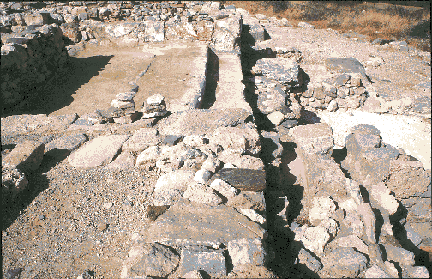 oor. They do not, however, fall outside the general pattern of construction
of the Petras west wing, for this building was raised on a system of six
west-east axes on deep foundations, between which shallower north-south walls
divided off the resulting space into rooms as required. oor. They do not, however, fall outside the general pattern of construction
of the Petras west wing, for this building was raised on a system of six
west-east axes on deep foundations, between which shallower north-south walls
divided off the resulting space into rooms as required.
Fig.5: Monumental staircase in the Central Court of the Palace at
Petras (photo: M. Tsipopoulou).
The west wing is divided in two by a corridor that runs to the west façade.
A very interesting area of the Protopalatial building is the complex of rooms
along the south edge of the preserved part of the west wing. The main room
is equipped with a plastered bench four meters long, a flagstone floor, and
orthostates along the walls. Based on the architecture, it is assumed to
be the sacred space of the first palace. It was discovered empty because,
after the MMIIB destruction (early 17th cent. BC), it was walled off and
sealed. Only the westernmost corner continued in use until the very final
phase of the palace, and was probably used as a shrine, as suggested by the
find of a plaster offering table. Access to the putative shrine was through
a rectangular room with a flagstone floor. This room continued in use until
the end of the palace. In the fiery Late Minoan IB destruction (15th cent.
BC), the walls were rubified in the intense fire, and from the upper floor
there fell numerous ashlar architectural fragments, some with mason's marks.
In the area
to the southeast of the palace, massive Protopalatial walls (19th-18th cent.
BC) came to light. They appear to be part of a unit comprising the large
rectangular building (4 H 15 m) to the south, as well as the eastern terrace
wall, and the bastion, a roughly rectangular projecting structure, preserved
to a height of 2.5 m. It forms part of the extensive defensive architecture
along the eastern flank, probably to be associated with the remains of a
massive fortification wall, preserved to a height of three meters, lower
down the side of the hill, just below the modern road leading to the site.
The Protopalatial period in eastern Crete saw substantial political tension,
leading to the erection of defensive structures at a number of sites, including
Petras.
The northern sector of the plateau is covered by the North Magazines. In
the Late Minoan IA period, the bedrock was cut back on line with the North
Façade to seat a substantial wall forming the southern limit of the
magazines. Their manner of construction was sufficient to support a substantial
weight, indicating that these magazines, some three meters lower than the
rest of the palace, carried at least one further story, if not two. A staircase
in the westernmost magazine supports this interpretation. In Late Minoan
IB, an additional magazine was added in front of the monumental staircase,
no longer in use. The excavation uncovered remains of some 30 pithoi (large
pottery storage vessels) on the ground floor, some with Linear A inscriptions,
while there was enough space for around 60 pithoi in the magazines. Of particular
importance was the discovery of a discoid label inscribed on both sides in
the Hieroglyphic script. The label was found with one of the pithoi in the
corridor, and was probably initially attached to a handle or to the lid.
This is the first evidence for the contemporaneous use of the two Minoan
scripts in Late Minoan I. In the area covered by the palace, no industrial
installations were uncovered. Since workshops form an important feature of
Minoan palaces, the search for them at Petras extended the excavation to
the southwest, onto a small plateau overlooking the main building. Here,
a series of rooms was excavated, containing half-finished stone vases and
various raw materials.
Although the palace of Petras is a small structure when compared to the
better-known buildings, a checklist of prerequisite features associated with
the building type sees every item except one present on the site, even if
only, as the case may be, in a modest manner. Fine ashlar masonry was
incorporated into the building at several points on the plan, and many blocks
were marked with mason's marks. The LMIB southeast entrance features a
pier-and-door partition. In addition, carefully cut jamb bases, column bases,
stairways, dadoes, and slab pavements, as well as dove-tail clamp cuttings,
and - not always a prerequisite in Minoan architecture - right-angle corners,
illustrate the care that went into the construction. Plaster floors are a
recurrent phenomenon throughout the several phases of the complex, some of
them being of a very high quality, comparable with the finest examples at
the large palaces. As a central administrative center, the site saw a continuous
traffic of subjects on official business; it was part of the Minoan way of
life to offer a drink (probably an alcoholic beverage) to the visitor in
a ritualized reception ceremony. The most common container was the conical
cup, ubiquitous at Minoan palatial and "villa" sites. Petras has produced
thousands of these cups, the majority from three major destruction deposits
connected with entrances. Wall paintings have also been preserved in
representative areas, although no figurative scenes have been found. The
administrative function was filled by substantial storage spaces associated
with the central building; the pithoi at the site are of the large size found
only in palaces. Writing
at Petras: The bureaucratic role of the palace is also indicated by the
presence of writing: scattered documents - including three Linear A tablets
- have come to light in several trenches; inscriptions, painted and incised,
appear on pithoi and small vases; and the Protopalatial northwest entrance
produced the Hieroglyphic deposit. This archive, fallen from the upper floor,
is probably the most well-preserved hieroglyphic deposit of the four known
on Crete. It came from a closed, securely datable context, and contained
inscriptions (fig.6), and a large number of sealings from 42 different seals,
including gold rings. 42 different seals,
including gold rings.
Fig.6: Clay bar with hieroglyphic inscriptions, from the Palace at
Petras (Photo: Erik Hallager).
Some of the material suggests that the archive was working at the time of
the catastrophe. This observation, unique for a Cretan archive, is of particular
significance for the reconstruction of the historical situation at the moment
of the destruction. It may also contribute to understanding the nature of
the catastrophe itself. The forced departure, coupled with the absence of
signs of violence, and the complete clearing out of valuables, argue for
a natural cause. An act of war is unlikely, given the undoubted continuity
of the time period leading into Neopalatial Petras. The houses in the settlement
were rebuilt, for all intents and purposes, immediately, and retained the
orientation of their predecessors. The palace was repaired, including the
major elements such as the Central Court, the monumental staircase, and the
North Façade, which continued in use into the first Neopalatial phase.
Dating phases at Petras: Most walls, floors, and alterations in the
palace at Petras are dated by the scraps of life - the shattered and scattered
remains of clay vases that, in the form of perhaps only one sherd from any
one vessel, form the main class of data recovered by the archaeologists.
A vast amount of sherd material corresponds with the moment that the previous
architecture on the plateau was torn down to make room for the palace in
its earliest form. In Middle Minoan IIA the entire plateau was transformed,
the old buildings (of which very little is known) torn down, and the surface
leveled by the removal of huge amounts of fill. This fill was carried down
the hill and deposited in a depression in an area in which the township was
later to flourish. It consisted of high quality sherds from vessels today
identified as mainly belonging to two ceramic styles, Light-on-Dark and Kamares.
On a number
of occasions, however, the dating of a level is provided by a destruction
horizon (the sudden cessation of all activity, a transformation brought about
in a non-orderly fashion). Four such horizons have been identified at Petras
on the basis of the pottery associated with them. The first is dated to the
Middle Minoan IIB period, and brings the Protopalatial palace to its end.
A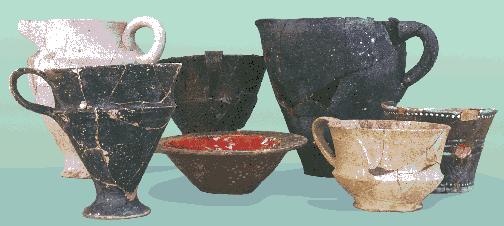 hieroglyphic archive associated with a number of vases fell down from an
upper floor into a doorway, where it remained undisturbed (fig.7). Although
small in size, this deposit proves that Petras functioned as a palace in
the Protopalatial period. hieroglyphic archive associated with a number of vases fell down from an
upper floor into a doorway, where it remained undisturbed (fig.7). Although
small in size, this deposit proves that Petras functioned as a palace in
the Protopalatial period. .
Fig.7: Middle Minoan IIB pottery found with the hieroglyphic archive
at Petras Palace (photo: M. Tsipopoulou).
Two destructions are dated to the Late Minoan I phase, the first in the IA
subphase, the second in IB. In both periods the palace was destroyed. The
main hint of these destructions is a large deposit of drinking cups, in an
entire pantry that crashed down from the upper floor, thus creating a thick
deposit consisting of pottery, bones, and other objects. The LMIA destruction
is not well-known from other deposits; on the one hand, it would appear that
the inhabitants had time to flee with their valuables, while on the other,
the immediate reconstruction would have removed much of the debris. The IB
destruction is spectacular: the smashed pantry from the upper floor; fallen
ashlar blocks, rubefied by the intense heat; an oil storage room going up
in flames and leaving a thick, black deposit; pithoi in the magazines and
in the Central Court destroyed. The inhabitants appear to have fled - none
were found in the ruins, and the precious objects had all been removed. The
fourth and final destruction horizon is that of the Late Minoan IIIB phase.
After a hiatus of perhaps a generation, the plateau was inhabited again,
no longer as a palace, but a modest village. Two or more houses were built
on top of the ruins. When these houses were destroyed, no spectacular deposits
resulted, and a silence of 26 centuries spread over Petras, broken only once,
when a Byzantine cemetery was established on the plateau in the late 12th
c. AD.
Conclusions: The palace of Petras occupies the center of a well-defined
economic zone which comprises its site catchment. On the slopes of Hill I
around the palace, a large urban settlement spread out. Three building complexes
have been excavated to date, producing large two-story buildings with
architectural refinements housing various economic activities, including
wine production, wool dyeing, weaving, stone vase manufacture, etc. The hill
was inhabited from the Early Minoan period onwards, always a prosperous
settlement with external relations. The economic and political functions
that led to the status of palace grew gradually out of the existing framework.
In Middle Minoan IIA, the existing architecture no longer sufficed and a
major transformation of the structures on the plateau of Hill I was undertaken,
resulting in the construction of the palace.
As the central place, Petras administered to the entire Siteia basin (fig.2).
The "villas" of Achladia, Zou, Prophitis Ilias, and Klimataria are to be
understood in this framework as answering to the palace in a tripartite
hierarchy, with each "villa" forming a local center for a number of farmsteads.
In the Minoan period, the sea extended far into the present day plain, the
coastline being at the base of the foothills. At the deepest reaches of the
bay lay the mouth of the Pandelis river. Consequently, Hill I lay on the
waterfront, with a protected anchorage in a small bay between Hills I and
II, and while Petras was not the large harbor facing the east that Bosanquet
had sought, and which Platon found at Zakros, it served as an important way
station on the route along the northern coast.
References:
Bosanquet, R.C. 1901. "Excavations at Petras." BSA VIII, 282-285.
Macdonald, C. and J. Driessen. 1997. The Troubled Island, Minoan Crete before
and after the Santorini Eruption. Texas, Liege, pp. 226-227.
Platon, L. 1997. "The Minoan 'Villa' in Eastern Crete: Riza-Akhladia and
Prophetes Elias, Praisos: Two different Specimens of One Category," in R.
Hägg (ed.). Acts of the International Symposium, The Function of the
Minoan "Villa." Athens, pp.187-202.
Rupp, D. and M. Tsipopoulou. 1999. "Conical Cup Concentrations at Neopalatial
Petras: A Case for a Ritualized Reception Ceremony with Token Hospitality."
In MELETIMATA, Studies in Aegean Archaeology presented to Malcolm H. Wiener
as he enters his 65th year. Liege, pp.729-739.
Tsipopoulou, M. 1990. "Potters' Marks from Petras, Siteia." Kadmos XXIX,
2, 92-106.
1994. "Evidence for a New Minoan Palatial Building at Petras, Siteia." Abstract
in AJA 100, 1996, 387.
1995. "Late Minoan III Reoccupation in the Area of the Palatial Building
at Petras, Siteia." Acts of the Symposium Organized by the Danish Institute
in Athens. August 1994: Late Minoan III Pottery. E. Hallager and B.P. Hallager
(eds.). Athens, pp. 209-257.
1997. "Palace-Centered Polities in Eastern Crete: Neopalatial Petras and
its Neighbors." In W. Aufrecht (ed.) Aspects of Urbanism in Antiquity, from
Mesopotamia to Crete. Sheffield, pp.263-277.
1998. "A New Hieroglyphic Archive at Petras, Siteia." Abstract in AJA 103,
390.
1999a. "From Local Centre to Palace: The Role of Fortifications in the Economic
Transformation of the Siteia Bay Area, East Crete." In Polemos, Le contexte
guerrier en Egee a l'Age du Bronze. Liege, pp.179-191.
1999b. "Before, During, After: Stratigraphical Trenches at the Palatial Building
of Petras, Siteia." In MELETIMATA, op.cit., pp .847-856.
Tsipopoulou, M. and E. Hallager. 1996. "Hieroglyphic and Linear A Inscriptions
from Petras, Siteia." SMEA XXXVII, pp.7-46.
1997. "A New Hieroglyphic Archive at Petras, Siteia." Kadmos, pp.165-167.
Tsipopoulou, M. and A. Papacostopoulou. 1996. "Villas and Villages in the
Hinterland of Petras, Siteia." In R. Hägg (ed.) Acts of the International
Symposium, The Function of the Minoan "Villa." Athens, pp. 203-224.
Tsipopoulou, M. and L. Vagnetti. 1995. Achladia. Scavi e ricerche della Missione
Greco-Italiana in Creta Orientale (1991-1993). Roma.
1998. "Workshop Attributions for some Late Minoan III East Cretan Larnakes."
In R. Laffineur and P.P. Betancourt (eds,) TEXNH, Craftsmen, Craftswomen
and Craftmanship, Acts of the International Symposium, Philadelphia, April
1996, Aegaeum 16, pp. 473-479.
This is an abridged version of the article appearing on pages 41-51 in Vol.3, No.3 of Athena
Review.
.
|
|