free
trial issue
subscribe
back
issues
Athena Review Vol.2, no.4
Book Reviews
The Barrington Atlas of the Greek and Roman World
edited by Richard J. A. Talbert
Princeton University Press, 2000. 175 pp. with 102 colored maps. ISBN
0-691-03169-X. $325.00 (cloth), with CD-Rom.
The Barrington Atlas, the first comprehensive
set of maps of Greek and Roman civilizations to be published in over 130
years, represents work by at least 140 experts and consultants in the antiquities
field from around the world, plus cartographers and technicians at Mapquest.com
(formerly Geosystems). Its contents cover geographically every documented
place penetrated by Greeks and Romans, and chronologically from archaic Greece
to the Late Roman Empire, 1000 BC to ca. AD 640. A CD-ROM map-by-map directory
listing is also included.
One major advantage the Barrington Atlas has over previous attempts is the
progress made in the field of computer cartography, combined with modern
aerial photo and satellite data. The compilers of each map, experts in the
archaeology and history of the area recorded, began with satellite data from
the U.S. National Imagery and Mapping Agency (NIMA) and its British counterpart,
the DMS. Modern manmade features were removed, and the compilers added the
archaeological discoveries and information about ancient coastlines, based
on various geological, historical and archaeological data.
Maps were constructed on one of four scales ranging from 1:150,000 to
1:5,000,000, depending on the density of relevant places and structures,
and include topography, geographical features, thousands of place names
color-coded by period, major construction projects such as aqueducts, roads,
bridges, cemeteries, and the occasional fort.
 Supplemental
information comes in the electronic directory on a CD-ROM (also available
in a two-volume print version for $150), which includes Adobe Acrobat Reader.
The directory opens to a table of contents organized by map. Each segment
begins with introductory information about the peculiarities of compiling
its corresponding map. Next is the directory, a chart with place names listed
alphabetically with their locations on the map grid, periods, modern names
and locations, and references. Similar charts for each type of manmade structure
follow. An extensive bibliography completes the already exhaustive amount
of mapmaking detail.
Supplemental
information comes in the electronic directory on a CD-ROM (also available
in a two-volume print version for $150), which includes Adobe Acrobat Reader.
The directory opens to a table of contents organized by map. Each segment
begins with introductory information about the peculiarities of compiling
its corresponding map. Next is the directory, a chart with place names listed
alphabetically with their locations on the map grid, periods, modern names
and locations, and references. Similar charts for each type of manmade structure
follow. An extensive bibliography completes the already exhaustive amount
of mapmaking detail.
The maps are beautiful, produced in full color and fascinating detail. Thanks
to the supplemental directory and the Gazetteer (index), the contents of
the maps are easy to locate and reference. This is a wonderful reference
volume for archaeologists and historians. A minor problem in clarity is the
periodization method. When a feature was active for only one of the five
periods (Archaic, Classical, Hellenistic, Roman, or Late Antique), its name
is underlined in the color corresponding to that period. Almost all designations
are of the later three periods, which are denoted by purple, red and orange
lines. Because of the small font size and some background colors, these are
sometimes difficult to differentiate. However, this is a minor flaw in an
otherwise exceptional work.
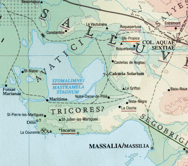
Fig.1: Map section around Marseilles (Massilia), with tax grid
in upper left.
Although the scope of the atlas is broad and previously unattained (including
major zones of Roman tax mapping or cadastration, as in the lower Rhone;
see fig.1), there is always more to include. For example, few smaller
archaeological sites are included, and other data (i.e., findspots of
inscriptions, battlefields, and searoutes) were excluded in the interest
of time and space. Likewise, most historical events were excluded in the
directory introductions, although some compilers have published these
independently. Assembling this atlas thus inspired the establishment of an
Ancient World Mapping Center at the University of North Carolina at Chapel
Hill to continue the expansion of this project. For more information, visit
the Mapping Center’s website at http://www.unc.edu/depts/awmc.
Abridged from Athena Review, Vol.2, no.4 (p.95).
Athena Review Image
Archive™ |
Paleoanthropology in
the News
| Guide
to Archaeology on the Internet |
Free issue
|
Back issues
Main index of Athena
Review |
Subject Index
| Travel
Pages |
Galleries and
Museums |
Ad
rates |
Current issue
index |
Copyright © 1996-2001 Athena
Publications, Inc. (All Rights Reserved).